
The Passage du Gois: A Unique Flooding Road in France
On the Cantabrian coast during the summer, incidents of tourists accidentally driving their vehicles into the ocean are not uncommon. However, in France, the Passage du Gois offers a different experience altogether: a road that sinks each day as the tide rises, creating a unique risk for those who dare to cross it.
Traffic and Tourism at the Passage
Despite its hazards, the Passage du Gois remains a popular route. In 2021, an astounding 387,823 vehicles traversed this road, according to data from the Noirmoutier Tourist Office. For adventurous souls wishing to experience this iconic location—known for its appearances in the Tour de France—crossing this route can be as exhilarating as it is risky.
Understanding the Road’s Unique Dynamics
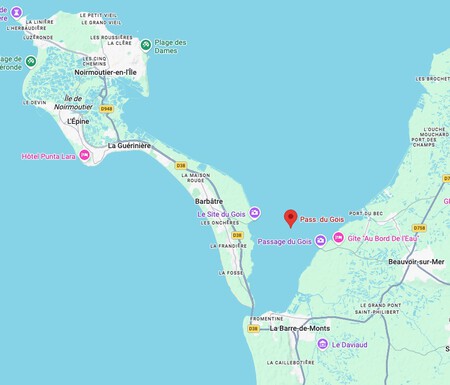
Measuring 4,125 kilometers in length, the Passage du Gois connects the island of Noirmoutier to the mainland at Beauvoir-sur-Mer, near Nantes. The deep waters of Bourgneuf Bay surround this road, which is part of the D948 network in the Vendée department. The road’s status—passable or submerged—is entirely dictated by tidal conditions. During high tide, the road can be covered by 1.30 to 4 meters of water.
The Passage du Gois on Google Maps
Cross With Caution
Before considering a crossing, it’s vital to heed the recommendations from the local tourist office. If the tidal coefficient is high, there’s a safe window of 90 minutes before and after low tide. However, low tidal scenarios drastically shorten this window, suggesting that one should cross only at the precise moment of low tide. Miscalculating the tide can lead to perilous situations on this four-kilometer stretch.
Safety Measures and Modern Challenges
Fortunately, there are nine safety beacons established since the 19th century where stranded vehicles can be left safely until assistance arrives. However, despite adequate signage, many people still fall victim to being swept by the rising tide. GPS systems often fail to account for crucial tidal information, complicating the navigation process. It is essential to remain vigilant and not solely rely on technology.

The movements of the tides in the Passage du Gois. Marine Hydrographic and Oceanographic Service
The Geological Wonder Behind the Road
The intriguing nature of the Passage du Gois stems from geological processes. The road formed due to the convergence of two opposing currents—one influenced by the Loire estuary and the other by the Atlantic. This phenomenon, known as wantij, involves particle deposition, which gradually elevated the seabed to create this remarkable roadway.
Challenges in Construction
The road was constructed between 1935 and 1939, a lengthy endeavor due to the restrictions of working only during low tide, limiting work hours to just two periods daily. As a result, it took five years to complete this unique pathway of cement slabs.
The Future of the Passage du Gois
While the Passage du Gois is neither the first nor the longest flooding road, it is among those most vulnerable to disappearing due to climate change. The IPCC estimates sea levels will rise between 0.38 and 0.77 meters by 2100, endangering coastal infrastructures like this one and making safe crossings increasingly impossible.