
LIVE Weather Update for CDMX and Mexico – Friday, July 3
Heavy Rains and Electrical Storms Expected
According to the National Meteorological Service (SMN), the early hours of today, from 03:00 to 06:00, are forecasted to experience heavy occasional rains accompanied by electrical shocks. Regions particularly at risk include Veracruz (Sotavento, Los Tuxtlas, Papaloapan, Olmeca) and Tabasco (Chontalpa).
In addition, intervals of showers with possible thunderstorms are predicted for extensive areas in the West, Northwest, North, and Southeast of the country. The Northeast will likely see scattered showers. In the Center and the Valley of Mexico, rain along with intermittent showers is anticipated in the State of Mexico, with isolated rains expected in Mexico City (CDMX) and its neighboring states.
Moreover, wind gusts of up to 50 km/h are anticipated in the isthmus and Gulf of Tehuantepec, putting certain regions on high alert for possible flooding, landslides, and downed trees.
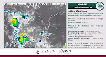
State-by-State Weather Forecast (00:00 to 03:00)
Forecast: Rain and intervals of showers with possible electrical shocks.
- Regions: Sierra Baja, Valle del Mezquital, Sierra de Tenango, Mining Region, Cuenca de México, Valle de Tulancingo, Altiplanicie Pulquera.
Forecast: Isolated rain.
- Regions: Sierra Gorda, Bajío Queretano, Sierra Queretana, and Central Valleys.
Forecast: Cloudy skies, no rain.
Forecast: Heavy occasional rains with electrical shocks.
- Regions: Olmeca, Huasteca Alta, Huasteca Baja, Los Tuxtlas, and Papaloapan.
Warning for Rain and High Waves
The SMN has issued a call for caution due to very heavy occasional rains (50 to 75 mm) expected in regions such as Chihuahua, Durango, Sinaloa, and Guerrero. Heavy rain is also forecasted for the Valley of Mexico. The precipitation may likely be accompanied by thunderstorms and hail, increasing the risks of flooding, landslides, and rising river levels.
Additionally, coastal areas should prepare for swells generating waves of 1.0 to 2.0 meters along the Pacific Coast and Baja California peninsula.
Sweltering Heat in the Northwest
As we shift to the northwestern regions, an extreme heatwave of 40 to 45°C is anticipated across certain areas:
- Affected regions include:
- Baja California (northeast)
- Baja California Sur
- Sonora
- Chihuahua (east and southwest)
- Sinaloa (north)
In the remaining coastal and northeastern states, temperatures will likely reach between 35 and 40°C.
Weather in the Valley of Mexico
For Mexico City and the State of Mexico, a cool morning will transition to a mild afternoon, featuring cloudy skies. Showers, heavy rain, thunderstorms, and potential hail are on the horizon, with maximum temperatures reaching 24 to 26°C in CDMX and up to 22°C in Toluca.
Conclusion
Today showcases the dynamic weather patterns affecting Mexico, with considerable rainfall in some regions and extreme heat in others. Stay updated with local forecasts and take necessary precautions to ensure safety from heavy rains and electrical storms while managing heat exposure.