

Surely once traveling through some point in Spain you have seen a plaque hanging on the facade of a historic building, town hall, or train station indicating the altitude of that place with respect to the sea level in the city of Alicante. Comparing the altitude of a city like Pamplona or Soria with respect to the Levantine city is a question that has a scientific answer, and today we will explore this fascinating topic.
The first thing to keep in mind is that the sea level is neither the same nor constant due to different tides; it’s also not uniform across the Earth. Each country establishes a specific reference point within its territory, known as the Reference Level. This serves as the basis for calculating altitudes. In Spain, this task was undertaken by the National Geographic Institute, which was inaugurated in 1856 specifically to create accurate topographic maps of the nation.
Historically, measuring altitude was challenging. Two centuries ago, the technology available was limited. Altimeters, readily found today in cars and mobile devices, did not exist, making the task of calculating altitude a laborious process that demanded an extreme level of patience.
In Spain, the decision to choose that reference point was also based on scientific criteria. The National Geographic Institute‘s publication from the tenth Hispanic-Portuguese Assembly of Geodesia and Geophysics explains that the selection of Alicante was not coincidental. For measurement accuracy, they needed a site with minimal fluctuations in sea level, thereby ruling out various locations on the Cantabrian coast where sea levels could shift by up to four meters during the day.
Four Years of Manual Measurements
With this criterion in mind, the scientists focused on the Mediterranean coastline. Ultimately, they chose Alicante, which is located in a bay where daily sea level variations are only a few centimeters. They discovered that the city also met other weather conditions necessary for accurate measurements, such as stable atmospheric pressure and seasonal consistency.
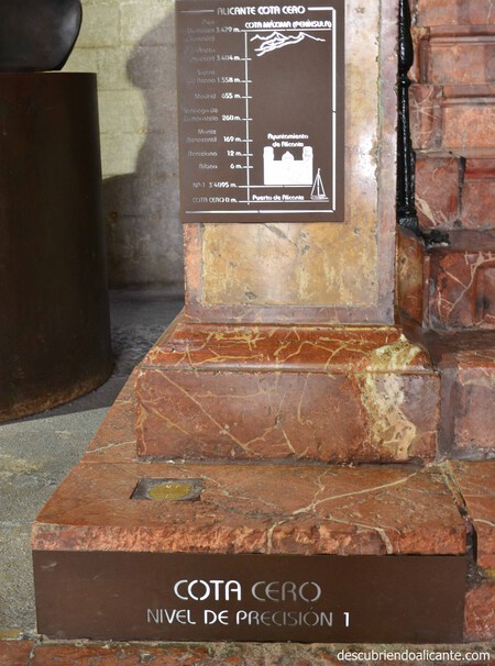
However, what might pique your interest is not merely the selection of Alicante, but the specific location for establishing the zero level. The scientists executed daily measurements manually over a span of four years, from 1870 to 1874, using a strip on the queen stairs located in front of the port of Alicante. After substantial effort, they designated the first step of the interior stairs of the City of Alicante as the reference point.
It was determined that this step was 3.41 meters above sea level. A plaque, marked “NP 1” for precision level 1, was installed there. Since then, this point has been the benchmark for all altitudes measured in Spain, with 3.41 meters added to their respective readings. As the institute explains, “from this point, the altitudes were transferred across Spain through a network that characterized the first high precision leveling network, known as Rednap.”
Over the years, as the port infrastructures in Spain expanded, the locations of the Mareographs also changed, and new stations were established to ensure data continuity. Presently, there are ten operational stations across the country, including Alicante 1, Alicante 2, Cartagena, Almería, La Coruña, Alborán (Isla de Alborán), and various locations in the Canary Islands.
Understanding how altitude is measured across Spain sheds light on the importance of precise geographical data. Efforts over the decades illustrate how critical it is to select specific points that minimize fluctuations for better accuracy. The choice of Alicante as the reference point may seem simple, but it represents a well-thought-out process backed by scientific research and extensive measurements.