
The Fire Triangle: Understanding Spain’s Devastating Wildfires
The situation is grave . If you open Google Maps and activate the “fire” function, you will notice a disturbing concentration of wildfires located in a specific ‘triangle of fire’ formed by the provinces of Ourense , León , and Zamora . This region is currently afflicted by notorious fires, such as those in Mozyuelas de la Carballeda, Yeres, and Queixa Chandrexa, which have already devastated thousands of hectares.
This region is not the only area in Spain suffering from such uncontrolled fires. However, the pressing question remains: Why do wildfires seem to target this region with such intensity?
The Spain that burns. August has proven to be a disastrous month for the country’s forestry. According to a recent report from the Ministry of Environment (Miteco), 138,800 hectares have been ravaged by flames as of August 10. This figure does not account for damage incurred during the subsequent week.
To provide context, consider that between January and early September 2024, wildfires consumed only 43,655 hectares . In comparison, the total destruction in 2023 was 89,000 hectares . Historically, the only other year that records a harsher comparison was in 2022, where approximately 215,000 hectares were burned by this time.
Is the entire country affected equally? No. Various regions such as Andalusia , Extremadura , Castilla-La Mancha , and Catalonia have also endured damage, but it is the area surrounding the triangle of Ourense, León, and Zamora that is particularly vulnerable to these changes.
A quick glance at Google Maps reveals that Chandrexa de Queixa has been especially hard-hit, impacting over 17,000 hectares . This event has led experts to deem it the most destructive fire in Galicia’s history . Additional fires like the one in Mozyuelas de la Carballeda have stretched across provinces, devastating large swaths of land.
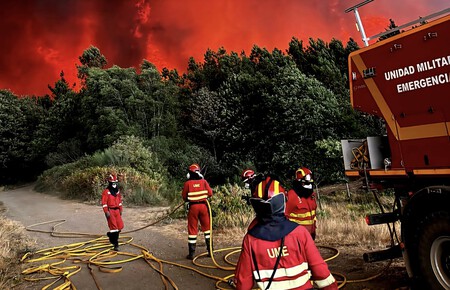
Understanding the Causes. The question then arises: what makes this region particularly susceptible to wildfires? According to Francisco M. Azcárate, a professor of ecology and environmental sciences, the repeat occurrences of fires in this triangle cannot merely be attributed to human negligence or poor fire management practices.
The reasons stem from more complicated structural elements tied to the characteristics of the land as well as shifts in land-use practices.
Meteorological Influences. Azcárate notes that the area’s climate is favorable for ecosystems that naturally experience a high frequency of significant wildfires. The interplay of wet and dry seasons leads to an accumulation of biomass that can become highly flammable. This interplay has been worsened by climate change, producing extreme temperatures that elongate the fire risk season .
Indeed, the ongoing wave of wildfires coincided with a heat wave that began in early August, which is already noted as one of the longest in history since the 1970s. To complicate matters further, flames become particularly challenging to control under what experts call the ’30-30-30 rule’: temperatures exceeding 30ºC , wind speeds over 30 km/h , and humidity levels below 30% .
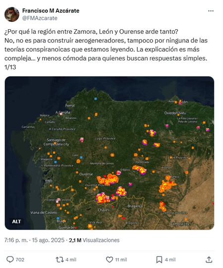
Click on the image to go to Tweet.
The Perfect Storm. Beyond climatic conditions, another crucial aspect lies in the region’s soil and topography. The soils here are typically acidic and less fertile, promoting more flammable plant communities. Additionally, the area’s abrupt terrain complicates firefighting efforts, making it difficult for effective management practices to succeed.
Urban depopulation is another factor increasingly discussed in relation to wildfires. As rural populations decline, agricultural and forestry lands are often abandoned, leading to a proliferation of wild vegetation. This pattern of land abandonment feeds the fires, making it easier for them to spread.
“The trend of depopulation creates a landscape that is more susceptible to wildfires,” warns Celso Coco , an expert in fire management. Where there were once diverse ecosystems supported by agriculture and grazing , we now see expansive, uninterrupted stretches of flammable vegetation.
Moreover, a longstanding misunderstanding of landscape management has resulted in the prioritization of dense forestry, seen as desirable, while underestimating the risks associated with fire. This imbalance ultimately exacerbates the impact of wildfires.
Images | Google Maps and ministry resources.
In summary, wildfires are a complex issue influenced by historical land use, climate changes, and ecological characteristics, particularly in vulnerable regions like the triangle formed by Ourense, León, and Zamora.