
The extreme heat has undoubtedly been the defining feature of last June. However, between warm episodes, we have seen the passage of troughs that brought us some thermal relief, accompanied by storms and even hail. Right now, we are in a phase of relief, but next week, the situation seems uncertain.
Cold air, hot air. Meteorologists expect the beginning of the week to stand out for an abrupt contrast between the north and center and south of the peninsula. The reason for this lies in the presence of two differentiated air masses: a cold one to the north and one of warm air to the south.
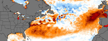
Rossby’s waves. To explain what happens at the atmospheric level, it is essential to detail one phenomenon involved: the not well-known Rossby waves . So, what exactly are these waves? They are atmospheric waves of planetary scale that mark the alternation of troughs and ridges in mid-latitudes , such as those covering our region.
These waves move from west to east , dragged by the meanders of the polar jet . In principle, waves are governed by a balance, known in meteorology as compensatory behaviors : if pressure drops in one area, it must rise in another.
Strange dynamics. We are entering unknown territory. Physicist and researcher JJ German recently explained on his Twitter account that as time progresses, conditions similar to those experienced in June should be “compensated” with opposite conditions in the coming weeks.
However, we face a problem : we are in uncharted territory. “This year, we have this strange dynamic, which might defy expectations,” states German. A trough is expected to “sweep” across the Iberian Peninsula, yet it will primarily touch the north and northeast , leaving the rest almost untouched.
This means everything indicates that after a series of hot episodes characterized by extreme anticyclonic conditions, the “calm” of the troughs may not arrive—at least not with the intensity we would hope.
What can we expect? The narrative appears to be repeating itself. The troughs currently providing some relief from the heat are anticipated to last briefly. In the upcoming days, another surge of heat is expected. During the early part of the week, a warm air mass will dominate the center and south, while a cold air mass lingers in the north.
The situation will resemble previous transitional scenarios, with heat coexisting alongside the emergence of storms . The State Meteorology Agency has activated multiple warnings for both precipitation and extreme temperatures for today and tomorrow.
In some areas of the northwest , we may experience situations where temperature warnings overlap with storm alerts. Starting Sunday, however, the expected alerts will predominantly be due to high temperatures alone.
Ultimately, while the climatic patterns and expectations may seem familiar, the nuances of this year’s weather present a distinct scenario. As we navigate through this turbulent meteorological landscape, we must remain vigilant and prepared for the dynamic changes that lie ahead.
Image | ECMWF