
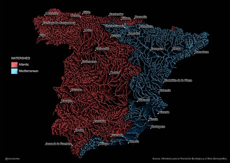
The Great Iberian Divide Explained
This fascinating map divides Spain into two distinct regions using colors to represent the final destination of each drop of rain. Each line drawn on the map indicates the many rivers flowing through the Iberian Peninsula, with blue denoting areas that funnel water towards the Atlantic Ocean and red indicating those that lead towards the Mediterranean Sea. This hydrological portrait offers an illuminating view of Spain’s river systems, revealing how geography dictates water flow.
Understanding the Continental Watershed
Crafted from data by the Ministry for the Ecological Transition and Demographic Challenge, Joe Davies, a cartographer and GIS consultant, created this watershed map that uncovers the continental watershed’s intriguing layout. The division runs primarily along the Iberian System and the Pyrenean foothills, splitting the country into two hydrological worlds. Intriguingly, while Spain may visually lean towards the Mediterranean, approximately two-thirds of its territory drains into the Atlantic Ocean. This paradox is not just a random occurrence but is rooted in Spain’s unique geology.
The Geological Influence
The geological structure of the Central Plateau plays a significant role in this division. It subtly tilts towards the Atlantic, a legacy of Hercynian tectonics from around 300 million years ago. This geological tilt is crucial in determining how rainwater is channeled through the land, resulting in varied river systems across different parts of Spain.
Notable Rivers and Their Unique Paths
One particularly noteworthy example is the Ebro River. Originating in Cantabria, just 20 kilometers from the Cantabrian Sea, it behaves contrary to geographical expectations; rather than flowing into the Atlantic, it journeys towards the Mediterranean, traveling almost a thousand kilometers. The Pyrenees serve as a barrier, and the Iberian and Catalan Systems act as funnels, compelling this river to flow westward instead of towards its natural oceanic outlet.
Another intriguing case is the Segura River, which starts in the Sierra de Segura in Jaén. Stretching over 300 kilometers to reach Alicante, this river has a notably low flow compared to the nearby Guadalquivir. This disparity can be attributed to extreme aridity in its basin and intensive agricultural pressures that sap its water supply.
Regional Highlights Based on the Map
In the context of Davies’ watershed map, Galicia stands out prominently in red due to its dense network of rivers. Receiving between 1,500 and 2,000 millimeters of annual precipitation, Galicia’s geology features predominantly impermeable granites and slates. This results in rapid drainage rather than filtration, contributing to a higher density of powerful Atlantic rivers and streams. If expanded to all of Europe, Galicia would remain a significant feature on water maps.
Interestingly, even cities like Pamplona appear colored blue on the map, indicating that its waters flow to the Mediterranean through tributaries of the Ebro, despite its proximity to the Cantabrian Sea. Conversely, Madrid is colored red, as the Manzanares-Jarama-Tajo rivers channel water towards the Atlantic. This juxtaposition unveils how drastically close localized regions can be to the continental divide, yet how differently they contribute to adjacent seas.
Conclusion: An Intriguing Hydrological Portrait
This map serves as more than just an artistic representation; it encapsulates the intricate interplay between geography, climate, and hydrology in Spain. By understanding this great Iberian divide, we gain insight into the country’s natural patterns and how they influence both ecological and societal attributes within the region.