
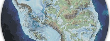
An international team of scientists led by researcher David Amblàs from the University of Barcelona has revealed a groundbreaking and intricate map of the Antarctic seabed. Utilizing the most comprehensive database available, they have identified 3,291 individual canyons organized into 332 systems, some plunging to depths of up to 4,000 meters. These canyons act as supermarine highways that regulate global climate while also posing risks to the massive glaciers of this icy continent.
The map that has changed everything. Previously, our understanding of the seabed surrounding Antarctica was limited and based on low-resolution data that only hinted at the largest structures. However, this has dramatically changed with the advent of the International Bathymetric Chart of the Southern Ocean (IBCSO) V.2. This new cartography merges thousands of ship polls with satellite data, providing a much clearer picture of the underwater geography.
Scientists took advantage of this “Google Maps” for the Antarctic seabed, employing semi-automatic hydrological techniques similar to those used to analyze river basins on land. This allowed them to trace the entire network of underwater “rivers” and systems that weave through the continent’s continental margins.
Two types of very different geographies. This innovative approach has unveiled two distinct types of underwater geography. The Eastern Antarctica features branching and tree-like canyon systems, indicating an ancient geological origin. In contrast, the Western Antarctica showcases shorter canyons with steep slopes and V-shaped sections, suggesting a more recent geological history.
According to Amblàs, this marked contrast in geomorphology supports the hypothesis that the eastern ice layer is older and formed before that in the west, a notion that had only been speculated until now.
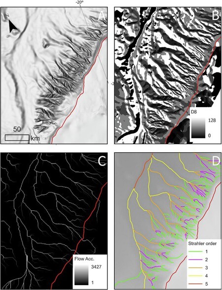
Visual representation of the applied methodology for extracting seabed streams.
Water highways that decide our future. These canyons are not mere geographical accidents; they are pivotal players in climate change. They serve as conduits for water from the continental shelf, which, when cooled and gains salinity, becomes dense. This dense water is funneled through the canyons to the ocean depths, forming Antarctic Bottom Water (AABW).
This mass of cold, dense water is the engine driving global ocean circulation, acting as a gigantic “conveyor belt” that distributes heat throughout the planet while sequestering significant amounts of carbon dioxide in the deep ocean. Hence, the geometry of these canyons is essential for climate regulation.
The Achilles heel of the glaciers. Conversely, these canyons also serve as entry points for Circumpolar Deep Water (CDW), a relatively warm mass of water sitting about 2°C above the freezing point. This warm water infiltrates beneath the ice shelves, accelerating the melting of glaciers and hastening their slide into the sea.
The discovery of such a dense canyon network, particularly in Eastern Antarctica—which has previously been deemed stable—raises concerns. It suggests that the continent’s vulnerability to ocean warming may be greater than existing models predict. Notably, regions like the Amundsen Sea, home to the pivotal Thwaites Glacier, are riddled with these canyons, acting as conduits for warm water.
The great challenge: refining climatic models. Furthermore, this discovery highlights a significant challenge: current climatic models used for projecting future scenarios are inadequate for accurately simulating these regions. The canyon topography is so complex that predictions about ocean dynamics and weather lose reliability, especially in vulnerable areas like the Amundsen Sea.
Thus, the researchers urge the necessity of investing in high-resolution mapping of these unexplored regions. Co-author Riccardo Arosio concludes that “new canyons will surely be discovered,” and each one is crucial for developing more accurate climatic models that could determine the planet’s future.
Antarctica is a well of surprises. Ongoing research continues to shed light on this remote continent, revealing intriguing findings. For instance, we already know that areas currently coated in ice were once lush forests, or that beneath its surface lies evidence of phenomena that defy explanation. These discoveries have attracted tourism, which poses its challenges.
Images | Cassie Matias
In Xataka | Thousands of marine ecosystems depend on only one thing: the fish and whale droppings.