
The Polar Cold Returns: What to Expect This Week
You might look at your thermometer and think that the “polar cold episode” has passed, especially with rising temperatures across the peninsula and heavy rainfall impacting the northwestern quadrant this Monday. However, this assumption would be a significant miscalculation. According to the Spanish Meteorological Agency (AEMET), the cold is far from over.
What’s on the Horizon?
AEMET warns that significant cold air masses will be making their way from high latitudes throughout the last week of November. While rain is expected to persist until Wednesday or Thursday, this storm is merely a precursor to an incoming wave of Arctic air. What follows is indeed complex.
This recent cold episode has been moderated somewhat, but due to sheer luck. The initial intrusion of cold air was shifted eastward through meteorological chance, preventing even harsher conditions from affecting us entirely.
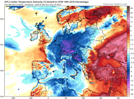
Last week (TropicalTidBits)
Understanding Temperature Variations
As pointed out by meteorologist M. Herrera, the current weather is surprisingly warmer than conditions typically expected for this time of year. With temperatures colder than in January in the central Mediterranean and warmer than those in July in the eastern Mediterranean, we narrowly escaped more severe weather. Had that plume of cold air drifted closer, the situation could have been much worse.
Weather Uncertainties Ahead
The week ahead promises to be notably colder than usual in most regions of the Peninsula and the Balearic Islands. However, the impact of these conditions remains uncertain, influenced by various unpredictable factors.
The Aftermath of the Cold Front
Typically, cold air intrusions correlate with less precipitation. Following the upcoming front, the forecast suggests we might return to a state of “meteorological misery” for several days, making the end of November and the start of December less than favorable.
Sudden Stratospheric Warming Concerns
Compounding these concerns is the looming shadow of sudden stratospheric warming. Recent developments have revealed unexpectedly strong warming trends, creating uncertainty about the weather’s trajectory as we move into December. While it’s unclear what these patterns might mean, many are wary of the possibility of experiencing a severe cold snap.
Water Supply Implications
One of the underlying issues remains the status of our water supply. Although recent rains have contributed to increasing dammed water levels, the overall trend is troubling, with water resources being consumed at a significantly faster rate compared to previous years. If the winter entails harsher conditions, the upcoming spring could also face complications.
In summary, while we may have had a respite from extreme cold, the arctic air is set to make a return. Staying informed and ready for rapid temperature changes is essential as we navigate through this transitional weather period.