
Understanding Hurricane Gabrielle: Its Path and Impacts
Hurricane Gabrielle has transitioned into what the National Hurricane Center (NHC) classifies as a post-tropical cyclone. Currently, the storm is crossing the Azores Archipelago, with forecasts indicating that it will make landfall on the Iberian Peninsula.
According to meteorological projections, Gabrielle is expected to arrive in Portugal this coming Sunday. However, its effects might start manifesting hours before it officially touches down, possibly as early as Saturday afternoon.
The State Meteorology Agency (Aemet) has noted a significant transformation in Gabrielle’s status, predicting it will become an extratropical storm. While there remains considerable uncertainty regarding the storm’s trajectory and intensity, it is anticipated that a broad swath of the Southwest Peninsula will experience unstable weather conditions over the weekend.
Gabrielle’s Journey in the Atlantic
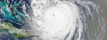
Gabrielle initially originated as a tropical storm in the central Atlantic, following a northwest path that brought it close to Bermuda. Before reaching the Azores, it intensified into a hurricane, making a 90-degree turn to continue heading northwest before redirecting itself toward the Iberian Peninsula.
Models suggest that Gabrielle’s most likely landing point is near Lisbon during the early hours of Sunday. Following that, the storm is expected to continue its southeast trajectory, aiming towards the Gulf of Cádiz.
Potential Weather Implications
Aemet underscores the “high uncertainty” surrounding Gabrielle, not just regarding its predicted path but also concerning its potential evolution. As a precaution, the agency has issued yellow alerts for parts of Western Andalusia, where rainfall accumulations of up to 30 mm in just six hours might occur. These alerts may be updated as the situation evolves and more precise information becomes available.
The general forecast from Aemet indicates that abundant cloud cover and rainfall are likely to affect nearly all regions of Spain. The southwest, in particular, including parts of the Cantabrian coast and the Mediterranean, is projected to receive the heaviest precipitation.
In terms of wind, there are not expected to be particularly strong gales due to the cyclone’s diminishing strength. However, moderate winds with occasional strong gusts could still be felt along the northwest coastlines and areas such as the Gulf of Cádiz and Balearic Islands.
Shifting Focus: Tropical Storm Humberto
While forecasters remain vigilant regarding Gabrielle, another storm, Humberto, is also approaching. Currently located in the Atlantic, Humberto is moving westward. Predictions suggest that this storm will turn north before making landfall in North America.
With Humberto’s path still in development, its trajectory is expected to shift towards the east later next week. As with Gabrielle, much remains uncertain, and it will take time to determine if this storm will impact the Iberian Peninsula or if its remnants will reach the region similarly to Gabrielle.
In conclusion, as Gabrielle approaches the Iberian Peninsula, residents and authorities must stay vigilant and prepared for potential disruptions. With the forecast indicating rain and moderate winds, it’s essential for communities to remain alert and follow updates from meteorological agencies. As the weather situation evolves, continuous monitoring will be critical for ensuring public safety and readiness for any extreme weather impacts connected to both Gabrielle and Humberto. Awareness and preparation will help mitigate risks associated with these dynamic weather patterns.