

Authorities Issue Flood and Landslide Warnings in the Dominican Republic
Current Weather Conditions
The Emergency Operations Center (EOC) and the Dominican Institute of Meteorology (INDOMET) have heightened concerns regarding severe weather conditions across the Dominican Republic. Despite the recent weakening of the trough impacting the region, hydrological risks remain high.
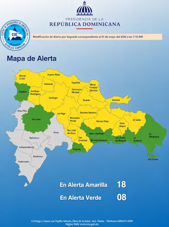
Currently, 18 provinces are under a Yellow Alert, while 8 provinces are on a Green Alert, indicating significant risks for floods, river overflow, and landslides.
Forecast for May 1
May 1 will start relatively stable but is expected to change dramatically. As the day progresses, the combination of the remaining trough, combined with daytime heating and local topography, will lead to severe changes in weather conditions.
Experts forecast scattered showers of moderate to heavy intensity, frequent thunderstorms, and gusty winds. There is also a possibility of isolated hailstorms in mountainous regions.
Alert Levels by Provinces
According to the latest COE alert map, most of the national territory is on high alert:
- Provinces on Yellow Alert (18): This signifies significant risk, with preventive evacuations recommended in vulnerable areas. Key provinces include Puerto Plata, María Trinidad Sánchez, and La Altagracia.
- Provinces on Green Alert (8): These areas are under surveillance, including the National District, Santo Domingo, San Juan, Peravia, and Dajabón. Residents are urged to remain vigilant.
Weather Variability and Recommendations
The National District will exhibit variable weather conditions:
- National District and Santo Domingo East/West: Expect a sunny morning, followed by cloud cover and isolated showers in the afternoon.
- Santo Domingo North: Increased activity with local showers, thunderstorms, and potential wind gusts.
- Temperatures: Highs of 29°C to 31°C and minimums ranging from 22°C to 23°C.
Preparedness and Public Safety
The INDOMET National Forecasting Center warns that soils remain highly saturated due to recent rains, urging caution for the following:
- Urban flash floods in poorly drained regions.
- Overflowing rivers and streams potentially isolating communities.
- Landslides in steep areas.
Residents are advised against crossing large bodies of water and are encouraged to heed the guidance of emergency services such as the Civil Defense and the Red Cross.
Looking ahead to the holiday on May 4, forecasts suggest a substantial decrease in rainfall from Saturday onward, though isolated thunderstorms may still occur, particularly in the Central Mountain Range and surrounding regions due to warming effects.
Stay updated through official channels and utilize the COE mobile app for real-time alerts.