
The January Chill of Palm Sunday
There is a line that connects something that happened 30 kilometers from the North Pole six weeks ago with the foremen looking at the weather report on the afternoon of Palm Sunday. And that line has a name: a cold episode as real as it is unusual.
Understanding the Cold Snap
-35 degrees at 5,500 meters. This chilling meteorological indicator encapsulates the harshness typical of the winter season as it approaches its end in March. However, while this cold snap brings extreme temperatures, we should refrain from exaggerating the implications as has been common in recent reports.
What’s Causing These Conditions?
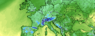
So what’s going on? The situation is straightforward: a powerful blocking anticyclone is forming between the southern British Isles and northern Spain. This blocking pattern is channeling a polar air mass across the continent. While Spain may experience a slightly warmer offshoot of this air mass, the temperatures remain unseasonably low.
Palm Sunday: The Climactic Cold
Palm Sunday, falling on March 29 this year, will mark the climax of this frigid onset. The two primary meteorological models indicate a staggering -35 degrees for the day. Much of the eastern third of Spain and the Balearic Islands will feel the chill, enveloping them in an unnerving “climate January” ambiance during the first half of Holy Week.
The Silver Lining
The good side. According to AEMET, the anticyclone is likely to block significant rainfall during most of the festive period. While it’s possible that “someday something will sneak in,” a limited amount of rain is expected across the majority of western and southern Spain.
What Can We Expect?
The complexity of this scenario cannot be underestimated. This winter has been exceptionally wet—registering as the wettest in nearly 47 years—with at least 19 impactful storms recorded, and reservoirs currently at 83.2% capacity.
Adding to this complexity, in early February, a sudden stratospheric warming event occurred at the North Pole, disrupting the polar vortex. What we are experiencing now aligns with predictions stemming from this event.
Impact on Holy Week
Holy Week serves as a media amplifier for this unusual weather.
What’s going to happen. It’s important to note that the snow level below 600 meters in the north will likely obstruct numerous roads, coinciding with increased travel. The uncertainty that prevails in the northwest complicates logistics for processions, and agriculture could find many blooming plants adversely affected.
Conclusion
This unfolds within the usual ‘playbook’ of Easter weather. It might not be a flawless week for festivities, but we should refrain from preparing for an all-encompassing “universal flood.”
Image | Tropical Tidbits