
Weather Alert: A Dramatic Change as Christmas Approaches
If you thought you had too much of a coat this week, now you’re going to have to think twice. After a few days marked by unusually mild temperatures for mid-December, the weather is set to change radically with the arrival of the peak days of Christmas.
A Thermal Collapse
So far, December has graced us with warm days where it felt pleasant to be out in the sun without a jacket. This warmth has been particularly noticeable in parts of the Mediterranean, including Almería and the Cantabrian Sea, where thermometers almost reached 20 degrees Celsius. However, this mild spell has a shelf life.
Starting December 21, coinciding with the official onset of astronomical winter, we can expect a notable thermal drop. According to AEMET, this transformation will not be gradual; rather, it will resemble a drastic collapse in temperatures, caused by a polar jet stream from the north. This will plunge minimum temperatures into the negatives, resulting in an overall thermal drop between 3 to 5ºC.
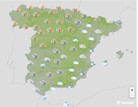
Rain and Snow
Before the temperature plummets, we will experience abundant rainfall as a new front approaches from the Atlantic. This weekend, significant storms are anticipated, particularly in northern Spain. Expect heavy rain across much of the peninsula, especially along the Galician coasts, where strong winds will generate waves exceeding seven meters in height.
Snowfall Forecast
As temperatures drop, rain may transform into snow across parts of the peninsula. Snow levels are projected to sink to between 1,000 and 1,200 meters in the northern regions. The communities most likely to be affected include Galicia, Asturias, Cantabria, La Rioja, Castilla y León, the Community of Madrid, and Castilla-La Mancha.
While this news may not sit well with everyone, those who cherish a White Christmas will likely rejoice. However, this weather shift may also cause significant traffic delays in the northern third of the country as holiday travel kicks into gear.
Outlook for Christmas Week
With Christmas Eve fast approaching, many are keenly focused on the weather forecast. AEMET indicates that after the front on the 21st, we can expect a cold environment with significant nighttime frosts across the peninsula. Widespread, albeit not extreme, rainfall is predicted, particularly in the southern regions.
The Canary Islands, however, will maintain stable weather, enjoying normal conditions for the holiday season.
An Extreme Change on the Horizon
Climate predictions from Europe suggest an unusual scenario that is worth mentioning. Specifically, the ECMWF indicates the possibility of heavy snowfall in the provinces of Seville, Huelva, and southern Badajoz on Christmas Eve. This would be historic, marking a rare event as Seville has not experienced a solid snowfall since 1954.
While these forecasts may change as the days progress, the mere idea of snow in Seville stirs excitement amid a backdrop of continuing cold temperatures.
Images | Osman Ran