
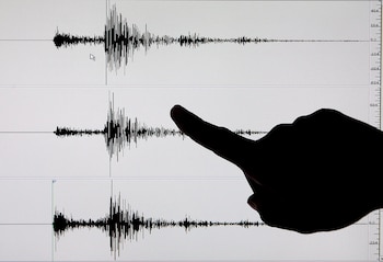
In the early hours of Thursday, July 10, 2025 , an earthquake with a magnitude of 4.2 shook the center of the department of Cundinamarca , Colombia. This seismic event was significant enough to be felt across several municipalities and raised concerns among residents.
According to the Colombian Geological Service (SGC) , the tremor occurred at 4:27 AM with its epicenter located 6 kilometers from Cucunubá , a municipality in the department. The earthquake prompted immediate responses from local governmental bodies and officials.
You can now follow us onFacebook and in ourWhatsApp Channel
The SGC released additional details, stating that the earthquake originated at a depth of 140 kilometers . This depth explains why residents in municipalities like Languazaque (8 km from the epicenter) and Ubaté (13 km away) reported feeling the tremor.
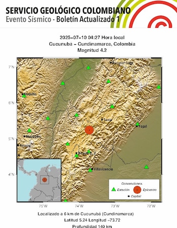
Reports from Blu Radio confirmed that residents in urban areas such as Bogotá , Villavicencio , and Tunja felt the tremor as well. Fortunately, the SGC stated that no significant damage or injuries have been reported thus far. This seismic event was detected by 60 seismic stations throughout Colombia, which facilitated prompt analysis.
Infobae Colombia sought insight from the Colombian Geological Service regarding the magnitude 4.2 earthquake. An official stated that despite receiving 18 reports of tremors, it is effectively a typical earthquake for the region. They noted, “It is an earthquake typical to the area near the Nest of Bucaramanga, although it is less common for this type of tremor to occur in the southern regions.”
Interestingly, there was another minor tremor detected on the same morning at 3:57 AM , located near Piedecuesta , Santander, registering a magnitude of 2.3 and occurring at a depth of 153 kilometers .
Although earthquakes generally last only a few seconds, their effects on the earth can persist for days, weeks, or even longer. In the aftermath of seismic events, the Colombian Geological Service identified ten common consequences, affecting both urban and rural communities.
These after-effects stem not only from the immediate energy release during the earthquake but also from the readjustments within the Earth’s crust that continue long after the incident. The disruptions can cause subsequent smaller tremors and may alter the geological stability.
Changing tectonic pressures can lead to minor aftershocks, increasing the likelihood of new seismic events nearby. Additionally, earthquakes can trigger landslides or rockfalls, particularly in regions with unstable slopes. In moist soils, the shaking may cause sediments to lose cohesion, resulting in a fluid-like behavior that can further destabilize the land.
Cracks and fissures may emerge in soft soils or along unpaved roads and paved surfaces. In specific regions, seismic activity can also release underground gases, including methane and carbon dioxide, alongside potential alterations to groundwater supplies.
In water bodies, the shaking can provoke erratic waves or flooding, noticeable in reservoirs, rivers, or lagoons . Other phenomena might include uneven terrain, fallen branches, and dust clouds in dry environments.
To ensure safety during earthquakes, the UNGRD (National Disaster Risk Management Unit) and the *Red Cross * recommend remaining calm, identifying safe zones at home or work, and maintaining an emergency kit. This kit should include essential items such as water, non-perishable foods, a flashlight, a battery-powered radio , and important documents, including duplicates of keys.

Participating in earthquake drills , designating family meeting points, and remaining informed through official communications further enhance safety preparedness. Checking for structural damages post-earthquake and avoiding open flames in case of a gas smell are equally crucial.