
Understanding Cloud Coverage in Europe
If we rely on popular clichés about European cities, Seville is often labeled as the “city of the sun,” while London is dubbed the “city of rain and clouds.” However, some locations deserve the reputation they carry while others do not. So, where exactly are the cloudiest places in Europe? NASA has dedicated over 25 years to monitoring this very phenomenon, and the answer is surprising—confirming that the United Kingdom does indeed feature prominently on that list.
Nasa’s MODIS Instrument and Its Role
In 1999, NASA launched the Terra satellite, equipped with the Medium Resolution Imaging Spectroradiometer (MODIS). This powerful sensor observes the Earth across 36 spectral bands, ranging from visible light to thermal infrared. It captures crucial data on temperature, water vapor, aerosols, and cloud cover simultaneously. This capability allows for the generation of cloud fraction products, providing spatial resolutions between 250 meters and 1 kilometer, based on the selected channel.
Revealing Patterns of Cloudiness
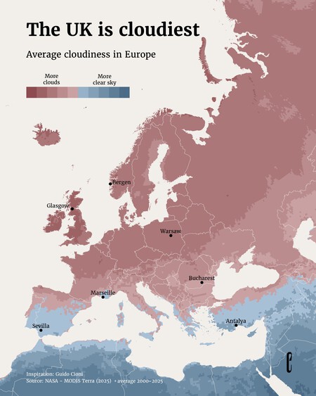
Utilizing data collected between 2000 and 2025, Italian meteorologist Guido Cioni developed a comprehensive map that clearly illustrates cloud coverage across Europe. A noticeable trend emerges: northwestern Europe consistently experiences higher cloud cover, whereas Southern Mediterranean areas enjoy clearer skies.
Consequences of Cloud Coverage
Cloudiness has significant implications beyond mere aesthetics. It impacts solar radiation levels reaching the Earth’s surface, influencing solar energy production, agricultural output, tourism activities, and even public health—with vitamin D levels being notably affected. The map created by Cioni includes valuable insights into the renewable energy dynamics of various European regions, uncovering why some areas rely heavily on photovoltaic energy while others take advantage of wind power.
Cloudy Europe vs. Sunny Europe
Cities such as Bergen in Norway and Glasgow in Scotland stand out on the map, depicted in intense red to reflect their persistent rainy climates and exposure to the North Atlantic’s harsh weather. Conversely, cities like Seville and Antalya in Turkey are depicted in blue, exemplifying typical dry Mediterranean and subtropical climates, with Marseille close behind.
This north-south pattern can be explained by climatic influences; Northwestern Europe regularly encounters Atlantic storms propelled by the polar jet stream, which drives moist air and weather fronts towards the region. As these fronts pass through, they generate clouds. In contrast, Southern Europe experiences the Azores High during summer, a high-pressure area that leads to clearer skies.
Data Limitations and Considerations
While the map and data offer valuable insights, there are caveats to consider. The Terra satellite passes each point on Earth only once daily (around 10:30 local solar time), so the data reflects specific moments rather than continuous cloud coverage throughout the day. Over 25 years of recorded variability helps smooth out unusual patterns, yet it is crucial to note that the data focuses solely on cloudiness and does not directly account for precipitation. An area may have a high density of clouds paired with little rain, whereas another can experience lesser cloud cover but concentrated, intense rainfall events. Finally, NASA notes that identifying clouds from snow in polar regions remains a challenge it continues to adapt to.
For those intrigued by climate data, the map not only sheds light on cloud patterns but serves as a comprehensive guide to understanding the climatic nuances across Europe.