
Understanding the North Atlantic Oscillation: Implications for Spain’s Weather
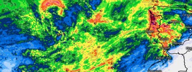
In recent days, Ibiza faced torrential rains, with more than 300 liters per square meter causing severe flooding. Yet, as we look ahead, there is life after Hurricane Gabrielle and the deluge that has affected the region. As we transition into a drier season, there’s a meteorological phenomenon that is pivotal to our understanding: the Positive North Atlantic Oscillation (NAO) .
What is Positive NAO? The North Atlantic Oscillation represents the oppositional relationship between the Azores High and the Icelandic Low , two predominant atmospheric forces that shape the weather across the North Atlantic . When the NAO index tips into the negative zone, the Azores High is relatively weak, allowing deep Atlantic storms to push further south, affecting regions closer to our latitude. Conversely, when the NAO index turns positive, as it currently is, moisture-laden storms reroute to higher latitudes, typically missing the Iberian Peninsula.
As we experience this shift in the NAO, the immediate result is a significant reduction in rain across the Mediterranean. For now, the storms will largely bypass us, redirected towards Iceland and the Nordic regions. However, this doesn’t imply a complete absence of precipitation. There might be residual showers due to the weak lifting and cold air flows; these will likely be sporadic.
Upcoming Weather Patterns in Spain
The start date of this change is imminent. From October 4 , we can expect a substantial transition in weather patterns throughout Western Europe . The southern regions of the continent will find themselves under the influence of a strong subtropical high-pressure system . The intensity of this high-pressure area suggests that temperatures will rise between 1 and 3 degrees above the seasonal norm, creating a dry and stable weather pattern.
However, the uncertainty lies in how long this situation will persist. Meteorologically speaking, we are entering autumn, a season characterized by great instability. It is essential to note that while the dry spell offers immediate relief from heavy rains, the unpredictability of weather patterns remains. The potential influence of fluctuating atmospheric conditions leaves meteorologists apprehensive about the longer-term effects on rainfall.
The Dangers of the North
While the current situation may appear optimistic, there are looming dangers. The positive phase of the NAO signifies a blockade in the west; nevertheless, it does not rule out developments from the north. A high-altitude cut-off low ( DANA ) can emerge unexpectedly from these latitudes, potentially disrupting the serene weather we’ve projected for the coming days.
Is this news entirely positive? The answer lies in a gray area. In isolation, the current weather scenario is neither unequivocally good nor bad—it’s merely a phase in the broader climatic cycle. Significantly, Spain’s reservoirs have reported better water levels compared to last year and the decadal average. This ‘water mattress’ provides a buffer, but the season’s critical nature cannot be overstated.
According to meteorologist Yurima Celdrán , autumn typically records more cumulative rainfall than winter in Spain. Thus, any loss of precipitation during this pivotal period may jeopardize water reserves. Should the country miss out on substantial rainfall, we will face upcoming droughts with fewer resources available. Water security becomes a crucial concern, as the ramifications of inadequate autumn rains could hinder the nation in managing future water shortages.
In conclusion, while the immediate future may present a dry spell, it is essential to remain vigilant and prepared for potential shifts in weather patterns. The balance between reservoir levels and seasonal rains holds significant importance for Spain, particularly as we navigate the unpredictable climate of autumn.