
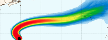
The Path of Hurricane Gabrielle: Key Insights and Predictions
In the last few hours, Hurricane Gabrielle has escalated to a Category 4 storm in the middle of the Atlantic Ocean. This development signals an urgent countdown, as the cyclone is expected to shift eastward and make landfall in the Azores by Friday. But the uncertainties don’t stop there.
The weather forecasts have been fluctuating in recent days, but clarity is beginning to emerge. In fact, Aemet has recently issued a public alert regarding the situation.
While it is now confirmed that the Azores will bear the brunt of the storm, probabilities are increasing for scenarios where the storm could also impact the Iberian Peninsula . Understanding its current position is vital for assessing potential effects.
Current Status of Hurricane Gabrielle
So, where is Gabrielle right now? According to the latest report from the National Hurricane Center in Miami, Gabrielle is currently located approximately 2,950 kilometers from the Azores and is packing sustained winds exceeding 220 km/h . The storm is advancing at a speed of about 20 kilometers per hour toward the northwest.
The Transition Ahead
After Gabrielle makes its way through the Azores , it is predicted to undergo an extratropical transition . This means that the storm will cease to function as a hurricane. Instead, its structure will shift from an intense, circular, and symmetrical form to a more expansive and asymmetrical configuration, resulting in a loss of intensity.
The Peninsula could see the remnants of Gabrielle arrive as a storm by the weekend—a phenomenon not uncommon during autumn months. However, the specifics regarding the timing, location, and manner of its transition remain less certain.
What This Means for the Iberian Peninsula
So, what are the implications of all this? Early forecasts suggest that Gabrielle will make an unanticipated approach toward our region, with heightened chances of undergoing an extratropical transition, potentially transforming into a highly intense storm.
Interestingly, as we head into the week, we can expect a mix of weather conditions. From Monday through Wednesday, a cooler atmosphere with showers is expected. However, by Thursday, we should experience a warm and stable climate, almost resembling a brief summer snapshot . This reprieve, however, is likely to be short-lived; shortly thereafter, we may witness deteriorating conditions, including rough seas, rain, and strong winds affecting the western part of the peninsula.
In summary, the trajectory of Hurricane Gabrielle is creating a state of heightened alert across several regions. With the storm’s projected path and potential transition into a storm , residents should prepare for a variety of weather scenarios. Authorities will continue to monitor the situation closely, providing updates as they become available.