
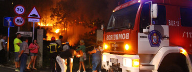
The Increasing Threat of Wildfires in Spain
The fires in Spain have become a pressing problem , particularly every summer. Amidst the relentless heat waves affecting the peninsular regions, fire-related issues are escalating without respite. The northwest quadrant of the peninsula has emerged as one of the areas most vulnerable to wildfires, marked by alarming data and maps indicating the present and future fire risks .
Fire Risk Analysis via Satellite Technology
The Risk Management Service of Copernicus , a land observation initiative by the European Union , provides critical insights through its mapping capabilities. Their detailed maps highlight the Areas at Greater Risk of Forest Fires across Europe. The maps utilize the Fire Weather Index (FWI), which classifies regions based on their meteorological fire risk—ranging from low to very extreme risk.
These maps allow for a clear visual representation of fire risks. Significant portions of the Northern Plateau , along with regions in the Cantabrian Mountains , Pyrenees , and Galicia , are designated risk levels above 2.5, indicating they are experiencing very extreme fire hazards.
Broader Implications in Southern Europe
Worryingly, the fire risk implications extend beyond the boundaries of peninsular Spain and the Balearic Islands. The maps reveal that regions under very extreme risk also encompass much of northern Portugal and a wide swath through the center and south of France . This alarming situation isn’t limited to the Iberian Peninsula; areas in the Balkans , Greece , Romania , Bulgaria , Slovenia , Austria , and Hungary are similarly affected. Moreover, anomalous risks have been observed in Nordic countries, particularly in Sweden , Norway , and Finland .
The Problem Is Set to Worsen
According to the Copernicus map, the current data from August 11 to 17 outlines an urgent situation. However, additional maps from the State Meteorology Agency (Aemet) provide insights into the evolving fire risks anticipated in the coming days. Far from presenting a rosy picture , these maps indicate a grim outlook.
Recent predictions connote an ominous trend. The maps displayed show extreme fire risks predominantly focused on Andalusia , Extremadura , the western regions of Castilla y León , and the Pyrenees . Notably, areas in Galicia , the Basque Country , and Murcia are similarly recognized as high-risk zones. Yet, forecasts indicate a worrying expansion of extreme risk areas, encompassing both the northwest and Extremadura.
As we approach the weekend, the “red spots” demonstrating extreme fire risk are projected to grow even larger. By Saturday, only select coastal locations and some mountainous areas will find relative safety from very high-risk conditions.
Facing the Devastation of Active Fires
In addition to forecasting imminent risks, Copernicus offers a perspective on the devastation caused by active wildfires. For instance, one critical event is the fire in El Arenal , Ávila , which has already ravaged nearly 1,800 hectares of land. This incident exemplifies the dire impact that wildfires can manifest on local ecosystems and communities.
In this dire context, Spanish firefighters apply critical strategies, including the well-known 30-30 rule , which emphasizes a tactical approach to managing fire situations effectively.
As summer progresses, it is essential for communities and local authorities to remain vigilant and prepared to face the increasing threat of wildfires. Enhanced awareness of fire risks, community education, and proactive measures could mitigate the impending devastation. Ongoing monitoring and strategic firefighting efforts will be vital to safeguard affected areas and restore ecological balance.