
June Heatwave: Spain Faces Record Temperatures
The first half of June has brought temperatures reminiscent of late July or even August. Numerous days have witnessed extensive areas in southern Spain exceeding the 40ºC mark. The concern now is not merely that the heat will persist throughout the summer; it is that there is a possibility it may intensify further.
Persistent Warmth Across the Peninsula
Same Trend. The heat seems intent on establishing itself over the Iberian Peninsula , as suggested by models utilized by the European Centre for Medium-Range Weather Forecasts (ECMWF) . To understand why, we must look upwards into the atmosphere.
Temperature Dynamics at 1,500 Meters
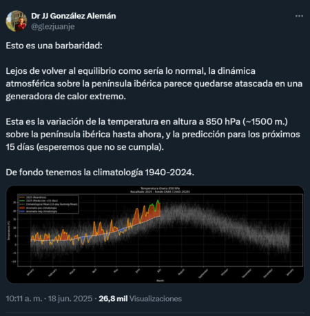
At about 1,500 meters. According to physicist, science communicator, and researcher at AEMET , J.J. Alemán, the clue lies in the temperature forecasts at 850 hPa, which corresponds to an approximate atmospheric height of 1,500 meters — a part of the lower troposphere.
The temperature at this level tends to correlate with the surface temperature, serving as a reference for how temperatures will evolve in the coming days. Data shared by Alemán indicates that not only are we encountering temperatures above the climatic average (an anomaly exceeding 5º Celsius ), but this situation is set to continue, with the possibility of this anomaly approaching 10º by the end of June.
Atmospheric Conditions Leading to Extreme Heat
“This is outrageous: instead of returning to equilibrium, as would normally occur, the atmospheric dynamics over the Iberian Peninsula seem to be stuck in a generator of extreme heat,” explained in his publication.
Mapping the Heat Forecast
Looking at the map. If we focus on the map created by ECMWF, we can see that heat is likely to remain overhead. The forecasts indicate that over the next ten days, nearly the entire Peninsula will be subjected to temperatures above 20º at 850 hPa, with vast areas exceeding 24º and some points temporarily surpassing 28º .

Understanding the Current Situation
What’s happening? In a second tweet, Alemán explained the underlying causes. He indicated that a cut-off low situated to the west of the Peninsula, along with a ridge (a broad area of high pressure associated with an anticyclone), are responsible for the current conditions.
This situation is further exacerbated by limited atmospheric movement, reaching what Alemán refers to as a “ quasi-static equilibrium point .”
Consequences of Extended Heat
The result: heat and more heat. The intuitive outcome is that the current warm spell appears destined to persist, at least throughout the upcoming week. Maximum temperatures in significant parts of southern Spain could remain above 36º and occasionally exceed 40º .
In Xataka : At the end of May, we reached 40ºC : it is merely the appetizer of the eleventh consecutive summer where temperatures are warmer than normal according to AEMET .
Image Source: ECMWF