
Understanding Urban Density Through Mapping: The Fascinating Case of the Blue Banana
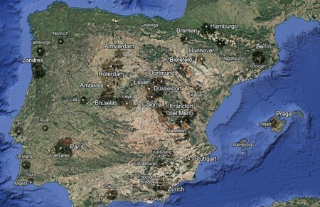
Maps are not just navigational tools; they are also fascinating visualizations of our world, sometimes bordering on art. However, their true potential and the complexities they represent can often be obscured. This is particularly true when considering vast territories. A recent map published on Urbanity.one sheds light on this topic with a unique approach. The creator has taken several major Central European cities from the so-called Blue Banana region and placed them on a map of the Iberian Peninsula, maintaining real distances between them.
This compelling map serves as a reminder of two critical insights. First, it illustrates the considerable size of Spain relative to its Central European counterparts. Secondly, it highlights how close these Central European cities are to one another, a crucial element for understanding the historical and economic development of the region.
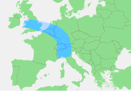
In the late 1980s, geographer Roger Brunet coined the term “Blue Banana” to describe the most densely populated and urbanized region of Europe. He defined a visual metaphor that connects the industrial cities stretching from England through the Netherlands , Belgium, Germany, and northern Italy. If you were to connect these urban centers, the shape that emerges resembles a massive banana, nestled between Manchester , Munich , Zurich , and Rome .
This might sound strange, but it makes perfect sense when viewed on a map. Connecting the cities along this industrial axis gives us the outline of the “banana” that Brunet envisioned. But how large is this imaginary shape? The answer often underestimates its size.
Madrid Proyecta shared a map that illustrates how this abstract axis is much smaller than one might think, especially when compared to Spain. The creator chose major metropolises along this theoretical line and positioned them on a map of the Iberian Peninsula while respecting real distances between them.
According to the map, for instance, Cambridge would be located approximately where Vigo sits, Rotterdam would align with Valladolid , Bremen would be at the height of Pamplona , and Stuttgart might easily find its place next to Alicante . Meanwhile, Paris would seemingly occupy a spot where Badajoz is located, while Düsseldorf would be where Madrid lies, and Linz , an Austrian city, would take the place of Barcelona .
Such comparisons evoke significant interest as they help us understand the vast scale of Spain . The Iberian Peninsula spans over 583,000 km² , with Spain covering approximately 505,000 km² , considering its insular surface area. This makes Spain one of the largest countries in the European Union, alongside France, Sweden, and Germany.
A country’s size impacts various factors such as population distribution and the delivery of services. The vast expanse of land presents both opportunities and challenges, particularly in urban planning and service facilitation.
Another compelling takeaway from the map shared by Madrid Proyecta is the actual proximity of Central European metropolises and their key industrial hubs, population centers, and strategic decision-making points. This nearness has played a significant role in shaping the development and integration within Europe.
Images | Urbanity.one and Madrid Proyecta (X)
In summary, the juxtaposition of Central European cities upon the Iberian Peninsula provides a new perspective on urban density and spatial relationships in Europe, revealing significant insights about regional development and infrastructure.