
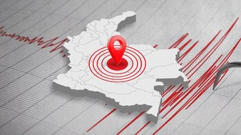
A sismo of magnitude 3.0 was recorded in the municipality of Paratebueno, Cundinamarca , according to preliminary information from the Colombian Geological Service (SGC). The earthquake occurred at 07:31 (local time) on June 11, with a depth of 128 kilometers, located at a latitude of 4.353780746 and a longitude of -73.17565155.
It’s important to mention that this information published by the SGC is preliminary and may be subject to changes or updates regarding the earthquake’s magnitude and exact location of origin. In Colombia, the intensity of earthquakes is measured with the European Macroseismic Scale (EMS-98), which starts at intensity 2, described as “barely felt” by very few people at rest. Intensity level 3 is categorized as “lightly felt,” where some objects may sway.
An earthquake is considered to have intensity 4 when it is “widely felt” by many people inside buildings and by a few outside. Windows, doors, and dishes vibrate. At level 5, “strongly felt,” small objects move, doors or windows sway, and minor cracks may appear in buildings or houses. Intensity level 6 implies “light damage,” where some people may lose their balance; some objects fall, and many buildings show light damage. Level 7 indicates “moderate damage,” meaning heavy furniture moves, many buildings have cracks, and wall coverings may fall off.
Finally, intensities above 7 result in “severe damage” : at this stage, many people have difficulty standing; heavy objects fall, and old or weak structures may collapse.
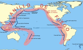
Colombia is considered a country of high seismic risk because it is located in the Pacific Ring of Fire , an area that hosts 75% of the world’s volcanoes and where approximately 80% of the strongest earthquakes globally occur. Known as the Ring of Fire, it includes the mountainous zone of western Argentina, Chile, Peru, Ecuador, Colombia, Panama, Costa Rica, Nicaragua, El Salvador, Honduras, Guatemala, Mexico, the United States, and Canada, then bends at the Aleutian Islands and proceeds down the coasts and islands of Russia, Japan, Taiwan, the Philippines, Indonesia, Malaysia, East Timor, Brunei, Singapore, Papua New Guinea, the Solomon Islands, Tonga, Tuvalu, and New Zealand.
In the specific case of Colombia, the country is located at two significant subduction zones, as it has the Nazca plate on one side colliding with the South American plate , while the latter also interacts with the Caribbean plate , leading to frequent earthquakes.
In this context, the departments of Nariño, Chocó, Caldas, and Santander are the areas where the most earthquakes occur; the latter houses the municipality of Los Santos, which is recognized as the second most seismic zone in the world .
Historical Earthquakes and Their Impact
Colombia-Ecuador of 1868
Two earthquakes occurred along the border of Ecuador and Colombia on August 15 and 16, 1868, with magnitudes of 6.3 and 6.7, the latter being the deadliest, lasting almost a minute. The first earthquake was recorded in El Ángel and La Concepción, while the second devastated the Ecuadorian city of Ibarra, reportedly causing around 70,000 casualties, including deaths and injuries from both countries.
Cúcuta Earthquake of 1875
Also known as the Andes Earthquake, this quake struck on May 18, 1875, with a magnitude ranging from 7.5 to 8.5, primarily impacting Cúcuta but also affecting the neighboring Venezuelan state of Táchira. While some estimates suggest up to 3,000 victims, only 461 bodies were located in the affected area in Colombia. The earthquake eventually revealed hot springs in areas today known as “Agua Hedionda,” “El Tampaco,” and “Aguas Calientes.”
1906 Earthquake and Tsunami
An earthquake of magnitude 8.8 struck the province of Esmeraldas in Ecuador, bordering Colombia, on January 31. This quake generated a tsunami that resulted in 1,500 deaths. According to SGC information, the waves reached heights of five meters, covering the Colombian region of Tumaco.
Páez Earthquake of 1994
This earthquake originated on the slopes of the Central Andes of Cauca in southwestern Colombia on June 6, 1994. With a magnitude of 6.4, it led to approximately 800 fatalities, primarily among the residents near the Páez River. It is considered the second deadliest in the country’s history.
Eje Cafetero Earthquake of 1999
This earthquake, regarded as the worst in Colombia’s recent history, affected the departments of Quindío and Risaralda, claiming over a thousand lives. The seismic event occurred on January 25, 1999, with a magnitude of 6.2. It severely impacted hospitals and limited emergency response resources, leaving around 4,000 injured and nearly 500 missing. Approximately 8,000 coffee farms were wholly or partially destroyed, and 13,000 structures of various types of businesses and industries were adversely affected.
In conclusion, Colombia’s positioning within the Pacific Ring of Fire renders it particularly vulnerable to seismic activity. This geological context has led to a historical legacy of devastating earthquakes, each leaving a significant mark on the nation. As the country continues to experience seismic events, understanding this risk is crucial for disaster preparedness and infrastructure resilience.
General News – 2