
## Weather Instability in January
As January comes to a close, it’s evident that Spain is experiencing significant weather instability across the entire territory. Weather maps for this week indicate a clear consensus from both the AEMET (Spanish Meteorological Agency) and the European ECMWF prediction model: a shift from stability to unpredictable humid winds is upon us. This transition will bring with it considerable rainfall, especially affecting regions along the Atlantic slope, notably Galicia and the Central System.
### Marked Rainfall
Forecasts indicate an extraordinary amount of rainfall for this week. Accumulations are expected to surpass normal averages, with the northeast potentially seeing increases of 60% above typical January levels. This uptick in precipitation can be attributed to the departure of Storm Ingrid, making way for the arrival of Storm Joseph, which will primarily impact Galicia.
In Galicia, rainfall accumulations may reach up to 90 liters per square meter, exceeding 150 liters in certain orographic areas. The Sierra de Gredos, the Pyrenees, and the elevated regions of Andalusia are also projected to experience substantial amounts of rain and snow as a result of orographic lifting caused by southwest winds.
### The AEMET’s Insights
AEMET has announced that this week will be characterized by fronts linked to Atlantic storms, causing widespread rain over most of the Peninsula and the Balearic Islands. Galicia is especially highlighted, as it will experience the most intense rainfall this week.
## The Thermal Paradox
Interestingly, despite the heavy precipitation expected, this week will not bring a polar cold wave. The thermal forecasts contradict what one might expect in such wet conditions. Since the winds originate from the Atlantic, they carry warm, humid air, resulting in unusually high temperatures. Maximum temperatures are expected to range from 10°C to 16°C, while minimums will remain between 8°C and 12°C, preventing severe frosts in lower areas.
### Limited Snowfall
Snowfall is mainly predicted for the mountain ranges across the peninsula. However, there is a possibility of snow on January 28 and 29 due to a cold front that could drop temperatures temporarily, affecting areas of the northern plateau and medium to low elevations. Nevertheless, this is expected to be a brief occurrence within an overall mild climate.
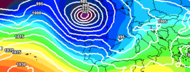
## Understanding the Storm Carousel
To comprehend the series of storms currently impacting Spain, it’s essential to examine the North Atlantic Oscillation (NAO) index. Presently, it is in a negative phase, which inhibits the Azores high-pressure system from performing its typical function. This allows storms to travel at lower latitudes, impacting Spain instead of deflecting toward northern Europe.
In conclusion, the current wet weather across Spain is a result of complex atmospheric dynamics, and while we brace for heavy rain and potential snowfall, temperatures will surprisingly remain mild. It’s crucial to stay updated with local forecasts as conditions evolve throughout the week.