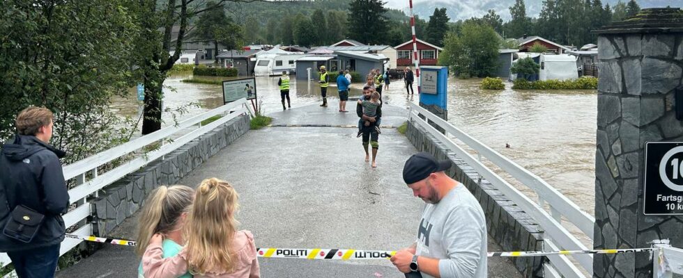
– It was difficult or impossible to know that the rainfall would come in Bø, says on-duty meteorologist Ingrid Bentsen. Neither the Norwegian Directorate of Water Resources and Energy (NVE) nor the Meteorological Institute issued a warning about the rain. Two campsites were hit. Roads collapsed and were closed. Cabin owners were isolated. Several homes were evacuated. – We are used to being notified. I was on the weather report myself and checked, and thought that this would go well. It was a very big surprise, says owner and operator of Åsgrav camping, Elisabeth Stenstad. The municipality set up emergency staff. Around 350 people had to be evacuated and find another place to spend the night. Twice as much came According to the weather forecast, there was a risk of heavy rain in areas a little further north in Eastern Norway. In the vicinity of the Bø river, 40 millimeters of rain was expected on Monday. Measurements show that twice as much came. As much as 80 millimeters of rain. – It is probably almost impossible to catch. It was very local, says Bentsen. What can we learn from this then? – We must try to learn from this situation, as we learn from all other such weather situations. It is difficult to say until we have summarized what went wrong on our end. NVE’s warning for Mid-Telemark showed that everything was normal at a green level before the flood occurred on Monday 22 July. Photo: Screenshot from NVE’s varsom.no service – Uncertainty It is NVE and the Meteorological Institute that issue danger alerts, including on Yr.no and varsom.no. The warnings are issued in the grades of yellow, orange and red danger warning. But the notifications were completely absent this time. Everything was marked green for Midt-Telemark. This is also confirmed by hydrologist Trine Jahr Hegdahl in the Norwegian Directorate of Water Resources and Energy, NVE. – None of the models showed that there would be a situation like this here. Trine Jahr Hegdahl, hydrologist in the Norwegian Water Resources and Energy Directorate. Photo: Snorre Tønset / news – Does it mean that the models are weak, or does it mean that it is something like this that you have to expect in the future? – The calculation models are the basis for rainfall forecasts. Then there is always some uncertainty about how a system moves, she says. There could be more flooding The last time there was a similar flood in the Bø river was in 2015. According to permanent residents news has spoken to, such floods were less frequent before. Meteorologists have previously warned that climate change could lead to more extreme weather. Among other things, there may be more torrential rain. – A single weather situation cannot be linked to climate change. But there may be more of this type of incident in connection with the climate changing. There will be more episodes of torrential rain in connection with climate change, says meteorologist Ingrid Berntsen. The big picture: Climate change brings more torrential rain Have you thought that summer days are more often interrupted by a sudden, intense downpour? Then you are right. Climate change has already led to an increase in extreme precipitation in Europe and Norway, according to the UN Climate Panel and the Norwegian Climate Service Center. Why is it raining more as the world warms? Swipe to read more. Javier Ernesto Auris Chavez / news The rain is gathering Man-made emissions of CO2 and other greenhouse gases have already made the world warmer. When it is warm, water evaporates into the atmosphere. A warmer climate also means that the atmosphere can hold more water, according to the climate panel. Therefore, a warmer world leads to more intense precipitation, especially in the summer. How much more torrential rain have we received? There has been both more rain and more torrential rain in Europe in recent years years, and it is linked to climate change, according to the UN climate panel. In Norway, too, the number of torrential rains, and the amount of rain that comes, has increased in recent decades. At Blindern, twice as many torrential rains have been measured as before, but the measurements are uncertain. How much worse will it get? So far, the world has become around 1.1 degrees warmer since pre-industrial times. For every degree the world gets warmer, the researchers expect almost a doubling of the number of extreme precipitation events. With today’s climate policy, the world is headed for 2.8 degrees of warming, according to UNEP. Published 24/07/2024, at 05.20 Updated 24.07.2024, at 08.52
ttn-69
The torrential rain in Bø was impossible to predict, say the meteorologists – news Vestfold and Telemark – Local news, TV and radio

