

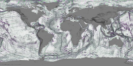
While humanity gazes into the cosmos for potentially habitable planets, Earth continues to unveil its hidden wonders. The ocean floor, a vast expanse largely unexplored, remains home to countless unknown species and geological formations. To shed light on these underwater mysteries, NASA launched the SWOT satellite in December 2022. This groundbreaking mission has resulted in the most detailed marine gravity map in history, enabling the exploration and understanding of underwater topography like never before.
The Revolutionary SWOT Mission
The SWOT satellite has mapped the ocean floor in finer detail than the last three decades combined, offering unprecedented insights. Beyond merely capturing the ocean’s surface, SWOT identifies subtle height variations in the sea, unveiling thousands of underwater mountains, trenches, and faults that traditional satellites fail to detect. This map serves not only as a geographical tool but a cornerstone for understanding our planet’s ecosystems.
Advanced Technology Behind the Map
Utilizing advanced phase coherence interferometry, NASA achieved high precision in measuring the two-dimensional height of sea levels. Historically, sonar technology mapped less than 30% of the seabed, significantly limiting our understanding. Conventional satellites provided low-resolution data, often around 8 kilometers. In contrast, SWOT’s mapping highlights intricate underwater landscapes previously hidden, revealing essential geographical features necessary for various fields, including oceanography, climate science, and biodiversity research.
Key Impacts of Detailed Ocean Mapping
The benefits of this detailed marine mapping extend beyond academic curiosity. Its implications are transformative:
- Biodiversity Preservation: Underwater mountains act as vital habitats, supporting diverse marine life. Recognizing their locations is crucial for conservation efforts.
- Navigation Safety: Knowing the locations of underwater peaks enhances navigation, mitigating risks for vessels traversing these waters.
- Climate Change Insights: Understanding the topography of ocean structures reveals how they influence ocean currents, which are essential for heat distribution across the planet.
Exploring the Depths: A 3D Experience
NASA’s innovative vertical gravitational gradient map has birthed an interactive 3D model of the ocean floor, allowing users to explore depths and geological formations virtually. This model illustrates abyssal hills—common underwater landforms stretching 200-300 kilometers—and previously concealed tectonic structures.
Additionally, the mapping highlights seamounts near Central America, which are underwater volcanoes crucial for modifying ocean circulation and nutrient distribution. Notably, SWOT reveals approximately 50,000 newly identified seamounts, each around one kilometer high, reshaping our understanding of marine biodiversity hotspots.
Tap to go to NASA’s 3D model of the seafloor. Via: NASA/JPL
Conclusion: Unveiling the Ocean’s Secrets
The insights gleaned from SWOT’s mapping of the seabed don’t just expand our geographical knowledge—they also have profound implications for biodiversity, climate science, and navigation safety. With this newfound understanding, we can better protect our oceans and ensure that they continue to thrive for generations to come.