
Ingemmet’s Identification of Critical Areas
The Geological, Mining, and Metallurgical Institute (Ingemmet) has identified fifteen critical zones for geological hazards in Áncash and La Libertad following a 6.0 magnitude earthquake that struck the northern coast of Peru. The earthquake’s epicenter was located just off the district of Chimbote on the night of December 27.
Seismic Emergency and Vulnerability
The seismic emergency exposed the vulnerability of these regions, raising concerns over risks related to landslides and rock falls. The earthquake, recorded at 9:51 p.m. with a depth of 52 kilometers, was classified as “very strong” by the Geophysical Institute of Peru (IGP).
Aftershocks and Ongoing Threats
Following the main tremor, residents experienced panic, and aftershocks were recorded, including a 4.1 magnitude tremor at 10:51 p.m. and a 4.3 magnitude shock at 12:17 a.m. on Sunday. These aftershocks further heightened fears among the local population, many of whom chose to stay outdoors to avoid potential landslides.
Critical Areas Noted by Ingemmet
Ingemmet’s technical studies have flagged eleven critical areas in Áncash and four in La Libertad vulnerable to seismic reactivation. Specific regions in Áncash include:
- Bolognesi: 5 zones
- Huari: 4 zones
- Huaylas: 1 zone
- Recuay: 1 zone
In La Libertad, critical areas are located in:
- Otuzco: 2 zones
- Chepen: 1 zone
- Sanchez Carrion: 1 zone
Public Health and Infrastructure Impact
The aftermath of the earthquake resulted in at least ten injuries in regions like San Jacinto (Áncash) and Chao Bridge (La Libertad). The Hospital La Caleta de Chimbote faced challenges such as falling tiles and structural cracks, yet remained operational during evaluations.
Community Response and Preparedness
Evacuation scenes were evident in supermarkets and public spaces, showcasing the earthquake’s impact on community infrastructure. Families residing in older structures or adobe homes opted to spend the night outside due to fears of aftershocks.
Experts like Hernando Tavera from the Geophysical Institute explained that the perception of the earthquake’s intensity varied due to soil type and building height, emphasizing the complexities of seismic experiences.
Looking Ahead: Recommendations and Community Preparedness
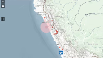
According to seismic impact maps, the affected corridor stretches from Tumbes in the north to southern Lima, indicating high shaking values along the coastline. Experts warn about the persistent threat of “seismic silence” and stress the importance of preparedness in these regions.
Civil defense authorities have reiterated the need for proper evacuation plans and emergency kits, and the experiences in Chimbote demonstrate the critical need for enhanced risk management education and infrastructure adaptations.
As the affected areas recover, specialized teams are assessing security conditions while encouraging public vigilance against ongoing seismic risks.