
Mallorca’s Nautical Treasure: The Legacy of Pere Rossell
Rediscovering a Historical Gem
Almost six centuries ago, the cartographer Pere Rossell created a comprehensive nautical chart that aimed to facilitate navigation across the Mediterranean. Designed to aid sailors in navigating the intricate coasts of North Africa and the surrounding seas, this chart is now seen as a cultural treasure. In an astounding move in 2025, the Consell de Mallorca invested 700,000 euros to reclaim this invaluable piece of history.
A Map Worth Its Weight in Gold
The notion that maps and manuscripts can be more valuable than gold is not new. Consider the atlas thought to have been used by Christopher Columbus, which fetched several million euros. In a similar vein, the Consell de Mallorca recognized the importance of Rossell’s chart, offering a modest yet significant investment to bring it back to its homeland.
The Cartographer and His Craft
Pere Rossell was a prominent figure in the Mallorcan cartographic school and produced nautical charts during one of Mallorca’s golden eras of maritime navigation. His maps gained immense popularity, sought after from regions as far as Flanders to Alexandria. This particular chart now acquired by the Consell is not just an ordinary map; it’s a meticulously crafted artifact that bridges history and navigation.
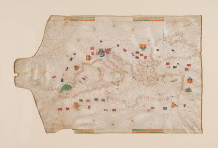
Encountering the Mediterranean on Paper
Local media have reported that the Consell’s plan is to display this chart at the Mallorca Museum, making its captivating details and historical annotations accessible to the public. The auction house Sotheby’s includes an extensive gallery of images showcasing the chart’s beauty. This particular map, created in the late 1440s, features place names, navigation routes, and even illustrations of city fortifications.
A Heritage Reclaimed
Antònia Roca, the head of Culture for the Consell, expressed pride in bringing this nautical treasure back to Mallorca, emphasizing its significance as part of the island’s maritime heritage. Many historians, including María Barceló, have highlighted the necessity of enriching Mallorca’s cultural assets, advocating for local institutions to act in reclaiming such historical pieces.
The Value of the Chart
Valued between 700,000 and one million pounds, the nautical chart is notable for being the oldest among ten maps authored by Rossell. Its rich heritage and craftsmanship offer insights into the art of navigation during its time. Originally commissioned by the influential Florentine Martelli family, the chart has traveled through time and now returns home.
Practical yet Artistic
Pere Rossell’s nautical chart stands out as it balances practicality with artistry. While many nautical maps of the period leaned towards minimalism for practical use, Rossell’s chart is elaborately designed, reflecting both aesthetic value and its role as a navigation tool. Ramón J. Pujades, head of research at the Barcelona History Museum, notes that this chart represents a unique convergence of functionality and artistry, transforming it into a coveted artifact.
This rediscovery of Mallorca’s nautical heritage not only celebrates its past but also acts as a beacon for future generations, highlighting the significance of preserving our cultural treasures.