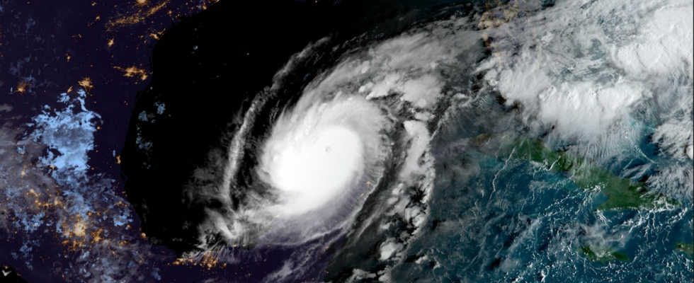
On Monday, Hurricane Milton underwent what is called an explosive intensification. Over the course of a day, the wind speed increased by as much as 145 kilometers per hour. It has never before been observed in a hurricane in the Gulf of Mexico. On Tuesday night, “Milton” passed just north of the Yucatán Peninsula in Mexico. It was then upgraded to category five, the highest category. The strongest winds in the storm were calculated to be 285 kilometers per hour. This is according to the National Hurricane Center in the USA. EVACUATING: One direction of the highway is filled with cars, the other almost empty. Overnight, people have gotten away from the west coast of Florida. Photo: AP Landing on Thursday Exactly where “Milton” will land is still unclear. The hurricane center warns that there is uncertainty in the calculations. Now the hurricane is headed for the big city of Tampa. – We must emphasize that this is a very serious situation. “Milton” has the potential to become one of the most destructive hurricanes to ever hit the central part of Florida’s west coast, the hurricane center writes. The wind can do a lot of damage, but it is the water that is often the biggest threat. – A large area on the coast will be exposed to a devastating storm surge. This is an extreme and life-threatening situation, reports the centre. In addition, the meteorologists at the center warn that the heavy rain from the hurricane can lead to flooding. That is what happened with Hurricane Helene two weeks ago. Close to 250 people have been confirmed dead due to the ravages of that hurricane. A LOT OF RAIN: Calculation of how much rainfall will come due to Milton. Photo: NOAA Lower speed, but bigger The part of “Milton” that has the fastest winds is now increasing in size. This means, among other things, that the area that will be exposed to destructive storm surges increases. – The forecast now shows that the area with strong winds will approximately double by the time the center of the hurricane makes landfall, the hurricane center writes. This expansion has meant that the wind speed is lower. “Milton” is a category four hurricane on Tuesday. The meteorologists expect that the speed will decrease further before the storm hits land. – “Milton” will still be an extremely dangerous hurricane when it approaches the coast on Wednesday, the hurricane center warns. UNCERTAIN COURSE: The US hurricane forecast is still uncertain where “Milton” will make landfall. Photo: NOAA Changing eyes That the wind field rises and the speed decreases has been observed many times in the past in powerful hurricanes. What happens is that the hurricane creates a new and larger eye. This is what happened on Tuesday night. “Milton” was a relatively small hurricane with a small eye when it reached category five. The categories are only about how fast the winds are, and not the size of the storm. The fastest winds stay in the cloud wall around the eye. In very strong hurricanes, this wall can be broken down and replaced by a new, larger one. The winds in the new cloud wall are weaker, until the hurricane literally picks up steam. STILL EYE: On Monday evening Norwegian time, “Milton” still had a small eye. It disappeared during the night. Photo: NOAA / AFP Heaters Hurricanes, or rather, tropical cyclones, get their energy from steam. Warm water giving off a lot of steam can, under the right atmospheric conditions, cause such a cyclone to form. The steam rises from the sea surface and turns into water droplets at altitude. During the transition from vapor to water droplet, energy is released. In large hurricanes, this energy is enormous. Far more than the electricity consumption in Norway. The sum of all this heat is a very strong, local low pressure. The low pressure sucks in moist air from the surroundings. This inflow keeps the engine running. The new moist air rises in the hurricane and leads to a constant replenishment of heat. Because of the Earth’s rotation, these inflowing winds bend. This is why the winds in cyclones rotate. THE ENGINE: The illustration shows how warm, moist air rises in a hurricane. Photo: NOAA “Milton” will get debris in the machine The meteorologists do not think “Milton” will be able to get up to category five again. This despite the fact that it passes over very warm water. The hurricane center believes that “Milton” will be exposed to crosswinds at altitude during Wednesday. It will destroy the important transport of moist air up from the sea surface. The heating machine, i.e. the steam transport, will not be switched off, but it will work so poorly that the speed of the strongest winds may be as low as 200 kilometers per hour when “Milton” goes ashore, reports the centre. Published 08.10.2024, at 16.23
ttn-69
Hurricane “Milton” can lead to disaster in Florida – news Urix – Foreign news and documentaries