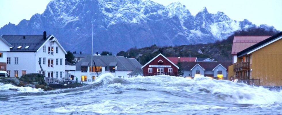
After the storm Berit in 2011, Kabelvåg square was under water. It will probably happen again, if the municipality does not take action. – We are well prepared to deal with this type of incident, but we cannot stop the sea, says emergency coordinator in Vågan municipality, Lars Ottermo Gärtner. Emergency coordinator in Vågan municipality Lars Ottemo Gärtner. Photo: Vilde Bratland Erikstad / news In 2022, the National Audit Office criticized the authorities for not having planned well enough for future climate change. This spring saw the report showing that the sea level will rise along Norway’s entire coast. The alarm was then sounded about a lack of funds and expertise in Norwegian municipalities. Today, the Directorate for Social Security and Emergency Preparedness (DSB) has come up with a new supervisor. It will help the municipalities prepare for rising seas. At the same time, the Mapping Authority has published a new map that shows what the water level may look like during a 20-, 200- and 1000-year storm surge, both today and in the year 2100. Check your municipality in the Mapping Authority’s new sea level map. Kabelvåg today Graphics: ØYVIND BYE SKILLE/news MAP DATA: THE MAP WORK AND NORWAY IN PICTURES Kabelvåg at the 200-year storm surge today Graphics: ØYVIND BYE SKILLE/news MAP DATA: THE MAP WORK AND NORWAY IN PICTURES Kabelvåg at the 200-year storm surge in the year 2100 Graphics: ØYVIND BYE SKILLE/news MAP DATA: MAPPING AND NORWAY IN PICTURES The DSB supervisor says that municipalities should plan with a 2100-year perspective when they have to take into account future sea level rise and high water levels. The challenges of rising sea levels are expected to become greater, and it is important to take a longer time perspective. Emergency coordinator in Vågan municipality Lars Ottemo Gärtner. Photo: Vilde Bratland Erikstad / news According to the Mapping Authority, the normal level in Kabelvåg may rise by 69 centimeters during this century. This means that the water will not recede again. When there are storms, floods and extreme rain, it settles on top of that again. – This whole area can be filled with water, says Gärtner and looks out over Kabelvåg square. If the sea level rises by one metre, just under 600 buildings in Vågan municipality could be flooded, figures from the Mapping Authority show. – Fortunately, this is not something that happens overnight. This is something that is included in the knowledge base when regulating new areas, adds the emergency coordinator. Drainage in Kabelvåg. Photo: Vilde Bratland Erikstad / news – The municipalities must do this now In some places in the country, the normal level may have increased by as much as 90 centimeters by the year 2100. – It is not just a threat, it is a fact. The sea has started to rise, and we have to plan for this where we will build and where we will live during the five-day period, notes DSB director Elisabeth Aarsæther. Director of DSB, Elisabeth Aarsæther. Photo: Erik Wiig Andersen / news The majority of the buildings we will be building in the next 100 years have already been built. Therefore, the guide is not only important for future building plans, but also for how the buildings we already have are to be secured. DSB’s advice and recommendations: Protection This strategy is characterized by the fact that, through physical security measures, one seeks to protect the population, buildings and infrastructure against high water levels, waves and erosion as a result of sea level rise. Examples of such measures that prevent water from entering during a high water event can be dykes, physical barriers/gates and embankments. With rising sea levels and the vulnerability of coastal areas, such a strategy alone will be both costly and have limited effect in the long term for the hardest hit areas. Adapt This strategy means that construction is still allowed in exposed areas, but that human activity, buildings and infrastructure are adapted to future sea level rise. It could be, for example, adapting buildings and infrastructure so that they can withstand the stress of high water levels from the sea, or nature-based solutions that allow the water to overflow at high water levels Avoid This strategy means that through land management you avoid new and extensive development in areas that will be affected by sea level rise. This can be solved in the area section by not facilitating new development in exposed areas. Furthermore, the municipality must consider taking out already designated construction areas and/or using the danger zone of high water levels from the sea with associated provisions to regulate what kind of development is permitted within the zone. Withdrawal This strategy assumes that the municipality should make some strategic choices related to the need for a planned withdrawal from affected coastal areas. This must happen before sea level rise poses a real problem for existing buildings and infrastructure. This can take place either through relocating, moving or giving up buildings and infrastructure. Such a strategy reduces the use of (costly) physical security measures, and lays down a plan for the possible relocation of buildings and infrastructure to areas that are little or not exposed to sea level rise and high water levels. For most municipalities in Norway, it is probably many years before such a strategy has to be put into use Source: DSB For garages and boathouses, a 20-year storm surge must be taken into account today. For ordinary houses and commercial buildings, allowance must be made for a 200-year storm in 2100. Hospitals, nursing homes and similar buildings must be equipped for a 1,000-year storm surge in 2100. National structures that are crucial for national or regional preparedness and crisis management must not be located in areas that may be exposed before high water levels. Fredrikstad is another municipality highlighted by DSB as particularly vulnerable: Fredrikstad today. Graphics: ØYVIND BYE SKILLE/news MAP DATA: MAPPING AND NORWAY IN PICTURES Fredrikstad with the 200-year storm surge today. Graphics: ØYVIND BYE SKILLE/news MAP DATA: MAP WORK AND NORWAY IN PICTURES Fredrikstad with 200-year storm surge in 2100 Graphics: ØYVIND BYE SKILLE/news MAP DATA: MAP WORK AND NORWAY IN PHOTOS Lack of funds and expertise – The municipalities must do this now. The buildings must stand for a long time and this cannot be waited for, confirms Aarsæther. However, the director is aware that not all municipalities will be able to implement all the measures now. Several lack both funds and expertise. – We must help the municipalities with concrete tasks and things they can do. There are many municipalities of different sizes and expertise, says the DSB director. Gärtner hopes the authorities will assist the municipality: – It’s not just Vågan municipality that is affected by rising seas, it’s the whole world. I imagine that some of these measures should end up at state level, at least at county level. There have been storm surges in Norway in the past. Here from Oslo in 1987: Snorre Tønset reports on flooding in the building area at Aker brygge. Published 01.07.2024, at 15.15
ttn-69
DSB asks Norwegian municipalities to prepare for increased water levels – news Norway – Overview of news from various parts of the country