
Discovery of a New Island in Antarctica’s Weddell Sea
In 2026, an international team headed by the SWOS research initiative embarked on a groundbreaking expedition aboard Germany’s Polarstern icebreaker. Their mission: to explore the Larsen Ice Shelf and its effects on global ocean circulation. But an unexpected storm diverted their course, leading to an astonishing discovery of a previously uncharted island in the northwest Weddell Sea.
The New Island: Geographic Significance
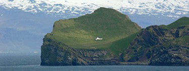
This newly found island, measuring approximately 130 meters long, 50 meters wide, and rising 16 meters above sea level, is located near Joinville Island, close to the Danger Islets. This area is notorious for its extreme navigation conditions due to hidden ice and treacherous waters. Until now, the island did not appear in any international cartographic databases, described vaguely as a “danger zone for navigation,” highlighting the imperative need for updated mapping efforts.
The Importance of This Discovery
From a geological perspective, the discovery underscores the fact that, despite advancements in space exploration, there are still undiscovered corners of our planet. The Weddell Sea, known for its challenging access and limited data coverage, promises further surprises. Traditional bathymetric mapping systems like IBCSO sometimes overlook or erase unmapped features. It’s possible this island remained hidden simply because no expeditions had employed the right tools to chart it.
This finding also reflects changes in environmental conditions. Since 2017, the region has experienced a retreat of sea ice due to warming surface waters, rendering a previously inaccessible area navigable. It poses a critical question: has the island always existed beneath the ice, or did it emerge more recently? Biologically, it presents a pristine laboratory for scientists to study unidentified flora and fauna, offering insights into how ecosystems adapt to climate change.
Weddell Sea: A Vital Component of Global Ocean Circulation
The Weddell Sea plays an essential role in global ocean dynamics, as it is home to the Antarctic bottom water, the densest and coldest water mass on the planet. This mass is crucial for regulating the exchange of heat and carbon across the globe. Recent changes in the dynamics of this region, particularly with the disintegration of the Larsen Ice Shelf, could have far-reaching consequences for oceanic conditions thousands of kilometers away.
How the Island Was Discovered
During the storm that redirected the Polarstern, Simon Dreutter noticed an anomaly on the charts. As the ship cautiously approached what appeared to be an unusually dirty iceberg, it was confirmed to be solid rock. Mapping efforts followed, utilizing methods such as multibeam echo sounding and drone surveying, which yielded the first elevation model of the island.
The Next Steps
Following the establishment of its coordinates, the new island will be formally named through a maritime tradition wherein the discoverer proposes a name. The data gathered will be incorporated into the International Bathymetric Chart of the Southern Ocean and updated nautical charts, removing any ambiguity surrounding its existence. This discovery opens avenues for further scientific exploration, including rock sampling to assess its geological composition and biological studies to examine how local ecosystems respond to climate fluctuations.
As we continue to uncover the mysteries of our planet, this new island signifies both the challenges and opportunities inherently tied to climate change, underscoring the urgent need for more extensive mapping and environmental research.