
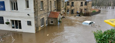
Understanding the Coastal Flooding Crisis
Concerns about global warming often center on rising sea levels and the potential flooding of coastal areas worldwide. Recent findings, however, suggest that many scientific studies underestimated this risk by measuring sea levels from an incorrect baseline. This critical error is not tied to the melting of ice or CO₂ emissions but stems from a miscalculation of what ‘zero’ sea level should be.
A Groundbreaking Study
A new study published in Nature has illuminated these flaws, indicating that coastal sea levels are an average of 30 centimeters higher than previously assumed. In particular regions, this discrepancy could even exceed one meter.
How Flood Risk Maps Are Created
To comprehend the problem, one must examine how flood risk maps are constructed. These maps rely on baseline measurements of sea levels; unfortunately, these starting points have proven to be flawed. Researchers found that over 90% of peer-reviewed studies from 2009 to 2025 utilized “theoretical geoids”—idealized models that assume a perfectly still ocean—as the basis for their sea level projections.
Real ocean dynamics differ significantly due to factors like winds, currents, and varying water temperatures. As a result, when researchers compared theoretical models with actual satellite altimetry and tide gauge measurements, discrepancies became pronounced.
The Global Implications
Adjusted global sea level measurements reveal an underestimation of 24 to 30 centimeters. While this might seem insignificant, this differential can spell disaster for coastal communities, making the difference between a secure coastal promenade and a flooded urban area.
Geographical discrepancies also surface: regions in the global South face much higher sea levels, with increases of one meter or more. Some localities might experience alarming rises of up to 5.5 or 7.6 meters.
Increased Flood Risk
The new models indicate that a projected one-meter rise in sea level could place 37% more coastal areas at risk of flooding than previously thought. This alarming revision places an additional 132 million people in potential danger.
No Change in the Rate of Rise
Despite these revelations suggesting a greater risk, the rate of sea level rise has not accelerated. The foundational error occurred due to starting from an artificially low baseline, creating a delusion of safety. Consequently, communities are closer to flood thresholds than previously believed, compressing the time available for essential preparedness measures such as building seawalls or relocating at-risk populations.
The Path Forward
To address this historical oversight, researchers have not only highlighted the error but also processed corrected data using advanced computational methods. This information is now available for public use, allowing governments and climate scientists to recalculate coastal risk assessments based on actual sea levels, rather than theoretical models.
As we face an uncertain future, understanding the realities of sea level rise is crucial. Communities must adapt to these changes to mitigate disaster and protect vulnerable populations.