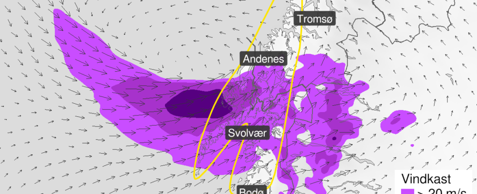
– Now we have sent out a yellow danger warning for gusts of wind in connection with this wind. Wind gusts of 25-30 meters per second are expected. Meteorologist on duty Haldis Berge tells news. Storm “Lillian” came from Great Britain and occupied southern parts of the country on Friday afternoon. Now it’s Northern Norway’s turn. In Narvik, the sold-out Haikjeften festival went off on Friday afternoon. Now the festival manager is preparing for the storm that will come on day two. Your own weather man at the festival – What is important is that people dress according to the weather. You have to dress warm and dry, but if there’s anything we Nordics can do, it’s exactly that, says festival manager Stein Hjertholm. Stein Hjertholm is festival manager for Haikjeften. He is ready to welcome the storm “Lillian” with open arms. Photo: Monia Kristine Buyle When asked if the festival has taken extra steps to protect itself against the storm, Hjertholm says that they have taken a special step. – We have very good routines for this with wind. We have an anemometer on stage, and a separate man who has one task. He will have continuous telephone contact with the meteorologist, who will update us all the time, so that we can be ahead of the curve and take the necessary steps. Your browser does not support the embedding of external content The festival is held in Bromsgårdparken, right in the center of Narvik. Hjerholm believes this is an advantage. – It seems to be a bit of a dump, so we don’t think it will be that bad with us, says the festival manager, and emphasizes that they are well prepared and sharp. – How much wind are we talking about before it becomes relevant to have people out of the festival area? – Taking action and evacuating, then it will be so windy that I think people will have left a long time ago – because then it is not pleasant to be here. Several ferries canceled – On Helgeland there can be strong gales in the morning and forenoon, and then it decreases in the afternoon, says the meteorologist. Possible consequences of a yellow hazard warning: Loose objects may be blown away Possibility of canceled departures for ferries, planes or other transport Bridges may be closed Some journeys may have longer journey times The power supply may be affected, for example as a result of trees breaking or coming into contact with the power grid Certain roads may be closed due to trees or other objects in the roadway The strong wind may cause locally high waves in fjord areas and lakes Source: Meteorological Institute Large amounts of precipitation and strong gusts of wind are expected in Northern Norway on Saturday. It will be worst north of Helgeland. – North of Helgeland, it is expected that it will increase to a westerly small storm, continues Berge. It is very windy in the Vestfjorden between Salten and Lofoten. This leads to canceled ferry connections on Saturday, informs Torghatten Nord: Bodø-Moskenes: Route A from Bodø at 11.00, and departure from Moskenes at 14.45. Route C from Bodø at 08:00 with return from the Mosques at 12:00. Bodø-Røst-Værøy-Moskenes: Route B from Bodø at 07:00, Mosques at 10:45, Værøy at 12:00 and Røst at 1:45 p.m. Published 24/08/2024, at 08.55 Updated 24.08.2024, at 09.22
ttn-69
– Has an anemometer on stage – news Nordland