
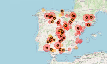
Overview of Recent Fires
The recent surge of forest fires in the Community of Madrid and various regions in Castilla y León has wreaked havoc, affecting over 60,000 individuals and burning nearly 15,000 hectares. Fire fronts remain uncontrolled, causing alarm among emergency teams due to the risk of different fronts merging. This could complicate efforts to extinguish the fires and hinder the return of evacuees. Fortunately, Saturday’s weather forecast suggests a significant drop in temperatures and wind changes, which might facilitate firefighting operations.
The Role of Wind in Fire Management
Authorities have identified wind as a critical factor influencing the fires’ development. The Madrid emergency service has confirmed that the fires are still active, and future progress largely depends on wind behavior over the coming hours. Understanding how wind patterns will shift is vital for strategizing firefighting efforts.
Real-Time Monitoring Capabilities
The evolution of ongoing fires can be tracked in real time via FiresSpain.es (xn--incendiosespaa-2nb.es), an independent monitoring platform. It consolidates data from official emergency services and utilizes satellite information from reliable sources such as NASA FIRMS, EUMETSAT SEVIRI, and Copernicus/EFFIS.
This platform provides:
- Automatic updates every five minutes, ensuring a precise overview of active fire outbreaks.
- Satellite data from VIIRS and MODIS, which can be a few hours behind but still offers crucial insights.
- Additional coverage from the Meteosat satellite with updates every fifteen minutes.
Ground Impact and Evacuations
The fires have significantly disrupted the road network, leading to 35 closures of regional and local roads early Saturday. In Guadalajara, 14 road outages have been registered, affecting towns including Tordelloso and Alpedroches. More than 13,000 people have been evacuated from areas like Cebreros and El Tiemblo in Ávila.
In Madrid, key roads allowing only emergency vehicles include the M-501 and M-512. The closure of roads extends to Teruel and Huelva, adding complications for both locals and emergency services.
Community Response and Support
To assist evacuated inhabitants, the Community of Madrid has established 14 reception points across various locations, including Las Rozas and Alcobendas. Authorities strongly advise against traveling to affected areas, including recreational sites, urging compliance with security force instructions to enhance the efficiency of emergency responses.
Current Evacuation Status
In the Sierra Oeste, ten locations remain evacuated, while confinement orders persist in several towns, including San Martín de Valdeiglesias and Villa del Prado. The fires’ progression continues to be influenced by wind conditions and meteorological predictions for the upcoming hours.
As this situation evolves, real-time monitoring and community cooperation are imperative in navigating the ongoing crisis.