
Exploring Housing Solutions: Proximity to Highways in Spain
With the ongoing housing crisis in major Spanish cities like Madrid and Barcelona, many are looking to less congested municipalities for more affordable housing options. However, the crucial factor in this decision is often the distance to a main road, which not only affects accessibility but also influences property value.
Personal Experience in Housing Choice
Having recently relocated, I can attest to the importance of easy access to highways. My new apartment offers direct highway access, and while the commute to my favorite padel club in Pamplona takes just 10 minutes longer than before, the cost savings have been significant. Conversely, living in a picturesque municipality in the Navarrese Pyrenees would have been a major mobility drawback despite its scenic appeal.
The Price of Proximity: Insights from Idealista Study
The reality of pricing variance is evident. According to a recent Idealista report, price differences can be as high as 131% in Madrid and 126% in Álava. For example, while Villagónadas de Abajo may boast lower property prices, its remote location can significantly detract from its appeal. Access to main roads is paramount; without it, affordability may not translate into livability.
An Analysis of Spain’s Geographical Divide
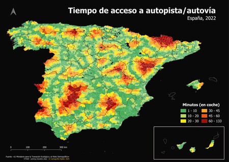
A revealing map from Digital Cartography, based on data from the Ministry for the Ecological Transition and Demographic Challenge, showcases the travel time to highways across Spain. This map uses a color-coded system to indicate travel durations: green areas represent up to 20 minutes while maroon indicates areas that take between one and 133 minutes to reach a highway.
Identifying Critical Areas
By overlaying demographic data onto physical maps, notable ‘red zones’ emerge, particularly in regions like the Asturian massif, Pyrenees, and areas along the muga with Portugal. These regions illustrate the pronounced effect of geographical limitations on accessibility and potential investment opportunities.
Understanding the Infrastructure Landscape
Spain’s infrastructure is notably centralized, with Madrid serving as the hub. Despite the absence of some connections on the map, routes like the A-2 leading to Barcelona and A-6 to A Coruña can easily be inferred. This illustrates the radial network model that creates significant gaps in peripheral regions, leaving them disconnected from important state and European corridors.
Challenges of Spanish Topography
Building infrastructure in mountainous areas, such as the Pyrenees and the Iberian System, poses extensive challenges, leading to inflated construction costs. Additionally, public projects are often evaluated based on a cost-benefit analysis, which becomes complicated in sparsely populated areas where daily traffic intensity remains low.
Environmental Considerations
Some red zones are also national parks or protected lands, creating further hurdles for development. Obtaining an Environmental Impact Statement for new projects in these areas can be nearly impossible.
Quality of Life: Traffic Comparisons
One of the most appreciated changes in my recent move to Navarra is the drastic reduction in traffic. The experiences during rush hour are manageable compared to the severe congestion in Madrid. Even though travel times may slightly increase, the overall stress of navigating through heavy traffic is substantially alleviated, providing a much more pleasant living experience.
Conclusion
As individuals consider leaving metropolitan areas for more tranquil settings, accessibility to main roads must remain a focal point. The spatial dynamics in Spain not only affect commute times but also dictate property value and overall quality of life. For those looking for more than just a home, embracing locations with reliable highway access is essential.