
The Storm Train: A Prelude to Greater Challenges for Spain
Current Weather Warnings
As of now, nine autonomous communities across Spain are under yellow weather alerts due to rain, wind, and various coastal phenomena. The catalyst for this unsettling weather is a “train” of fronts originating from the depths of the Atlantic Ocean, set to sweep across the Iberian Peninsula. This situation not only raises immediate concerns for those in affected areas but also hints at a broader and more complicated meteorological scenario.
Forecast: What to Expect
Weather models have started to align, revealing a clearer picture of upcoming conditions. Key points include:
- High Waves: Expected wave heights may reach up to five meters along the Cantabrian coast and off the shores of Galicia.
- Strong Winds: Gusts could easily hit 61 kilometers per hour, especially in northern regions.
- Rain Accumulation: While no significant rainfall is anticipated in the short term (a peak of around 15 l/m² in Huelva and Cádiz), areas such as Galicia, Zamora, Ávila, and Cáceres might experience substantial rainfall due to already saturated soils. Winds are forecasted to exceed 70 kilometers per hour across much of northern Spain.
Understanding the ‘Multiplier Risk’
The significance of these weather patterns can be boiled down to a concept known as “multiplier risk.” Unlike a singular event of intense rainfall, the continuous recurrence of these fronts poses increased operational hazards. This phenomenon is akin to a “calabobos,” where light rain may not seem concerning but ultimately leads to widespread moisture accumulation across regions.
One pressing issue is whether an “atmospheric river” will form—a scenario in which humid, warm air from the Gulf of Mexico merges with these incoming fronts, potentially resulting in a more severe weather event.
Normalcy in an Abnormal Context
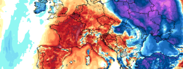
Amidst these weather phenomena, it is crucial to note that what is considered “normal” is shifting. Recent cold spells in Spain have begun to veer away from historical averages. Such a changing landscape complicates the weather dynamics, especially with a significant amount of snow accumulated from previous storms.
Preparing for the Future
The overarching question is, how long will this corridor of storms persist? As we approach summer, the anticipation of how quickly swamps fill and whether this moisture will have long-term ramifications on agriculture and the ecosystem becomes ever more critical. The current weather conditions may only be the beginning of a more extensive cycle of storms and potential agricultural crises.
In summary, while Spain braces for immediate weather disturbances from this train of storms, the multifaceted risks unveiled by this evolving situation require thorough awareness and preparedness. The pattern of rain, wind, and associated phenomena is not merely a transient challenge; it signals a potential environmental shift that could have lasting implications for the region.