
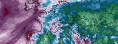
Yes, there’s a “negative NOA” and a “train of storms”, but AEMET informs us that during the upcoming Constitution Bridge long weekend, we can expect predominantly sunny skies and above-normal temperatures in many regions. After the persistent rain on the northern front, a shift towards clearer weather is on the horizon.
Understanding the Rhombus Phenomenon
But how can this be happening? What meteorological forces are at play that allow for this unexpected stretch of good weather? This brings us to the concept of the rhombus phenomenon. Named by meteorologist Luismi Pérez, the term vividly explains a specific atmospheric configuration diverting cold Arctic air to North America. Instead, Spain enjoys stabilizing conditions with warm temperatures and reduced rainfall.
What Conditions Are Required?
For this rhombus phenomenon to unfold, four specific air masses must be in place:
- A robust anticyclone over Newfoundland and Greenland
- Another anticyclone located in the Mediterranean area
- A storm in the Azores
- And yet another storm over the Scandinavian peninsula
When arranged on an isobaric map, these elements create a visual representation resembling a rhombus.
Significance of the Rhombus
From a meteorological standpoint, this rhombus is crucial because it establishes a type of atmospheric blockage. It results in a reconfiguration of the polar jet stream and modifies the trajectory of storms, distancing Spain from colder conditions. If the “head” of the weather system is the storm train, then the “tail” creates brief periods of warmer, stable weather.
Forecast for the Coming Days
As elucidated by Pérez, this rhombus effectively pushes the frigid air accumulated in Greenland toward North America rather than dropping it over Europe. Subsequently, Spain, under the influence of storms from the Azores and the Mediterranean anticyclone, will benefit from westerly and southwesterly winds that contribute to more temperate weather conditions.
Long-Term Implications
However, there’s a concerning backdrop to this pleasant weather pattern. Changes in atmospheric circulation over the Atlantic Ocean are causing more frequent episodes of stability, clear skies, and an absence of weather fronts during the autumn and winter months. While this trend can be interpreted as “nice weather,” it poses significant risks, aggravating structural droughts and complicating agricultural, water, and energy management.
Thankfully, the forecast indicates that this stretch of good weather won’t last long—just enough for us to enjoy the Constitution Bridge.
Image | ECMWF
In Xataka | The most beautiful, exciting, and hopeful thing about November has come out of England, and it is a weather forecast.