
The Chilling Reality of Hurricane Melissa
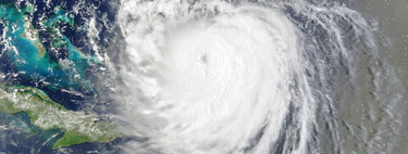
“I am speechless at how chilling these images are.” Those were the poignant words from the meteorologist behind Backpirch Weather, highlighting the fears of experts as they observe Hurricane Melissa’s rapid intensification. Reaching staggering speeds of 233 km/h and a pressure of 941 mbar , Melissa is currently situated 185 kilometers south-southwest of Kingston, Jamaica . This incredible display of nature has generated a sense of urgency, as experts warn that the hurricane is closing in on Category 5 status , threatening the island with damage “with little or no precedent.”
Over the past few days, Melissa has captured the attention of the meteorological community, becoming a focal point for those monitoring the hurricane corridor. Curiously, she began her journey moving extremely slowly , clocking speeds as low as three kilometers per hour at one point. Presently, she has managed to ramp up her speed to around seven kilometers per hour . Such slow movement is alarming, especially considering recent research indicating that hurricanes are exhibiting a declining speed trend, which often correlates with increased flooding and storm surges .
Hurricane Melissa is not merely following a worrying trend ; she seems intent on becoming a significant event in her own right. As reported by Meteored , Melissa has undergone explosive intensification , meaning we may see her escalate to Category 5 status before she makes landfall in Jamaica. In just 12 hours , the hurricane has transformed substantially. Moreover, predictions from the European model anticipate rainfalls exceeding 500 mm in affected regions, particularly in eastern Jamaica, southwest Haiti, and parts of Cuba.
However, as meteorologist Michael Lowry pointed out, Melissa demonstrates the unpredictable nature of hurricane intensity, especially at peak levels. Nonetheless, it’s evident that “the mighty Melissa stands firm,” as videos pouring in from the region depict terrifying conditions. These serve as a grim reminder of the hurricane’s potential impact.
Predicting the Unpredictable: What Lies Ahead
<pThe stakes are incredibly high as Melissa inches closer to landfall. Álvaro Oliver clarifies that Melissa is currently classified as a Category 4 storm but warns that it could see wind speeds “exceeding 250 km/h.” The slow movement of the hurricane is particularly troubling, heightening the risk of intense rainfall and potentially catastrophic flooding in the coming days.
In response to this looming threat, planners in Cuba are set to displace almost a million people , while the situation in Jamaica is more precarious, leaving residents with few escape routes. This complex combination of factors could trigger a disaster in slow motion , as the hurricane’s impact unfolds over the next few days.
Urgent Need for Preparedness
<pThe next few days will be crucial—not just for saving lives but also for gaining insight into why the Caribbean region is becoming increasingly hazardous for its inhabitants. As climate change continues to intensify storms and influence their paths, understanding these patterns will be essential for improving future preparedness and response strategies.
The images coming out of Jamaica and surrounding areas are stark reminders of the hurricane’s strength and unpredictability. As the countdown to Melissa’s potential impact ticks on, experts urge local communities to remain vigilant and prepared for whatever may come. The Caribbean is facing a daunting challenge, one that cannot be underestimated.
As we observe Hurricane Melissa’s behavior and its effects on natural systems, it becomes clear that comprehensive strategies and community readiness could help mitigate the catastrophic consequences that storms like this one can bring.
Image | CIMSS (via Alvaro Oliver)
In Xataka | If the question is what happens when a hurricane enters an extratropical transition, we will see the answer on Sunday: Gabrielle is at the doors.