

The Ongoing Rainfall in Mexico City: What to Expect
The City of Mexico, along with various regions across the country, has been experiencing intense rainfall in recent days. On this June 17, 2025, the forecast is no different. The National Meteorological Service (SMN) has confirmed that precipitation will continue in the CDMX, accompanied by showers, thunderstorms, and possible flooding.
In addition, the newly formed Tropical Storm Erick in the Pacific Ocean, off the coast of Chiapas, reinforces the predictions of heavy rainfall in different areas of the country, including the Metropolitan Zone of the Valley of Mexico.
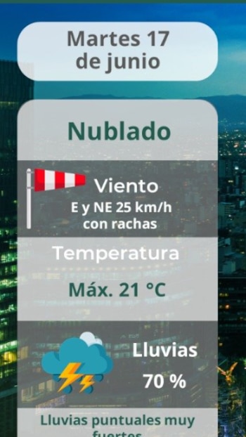
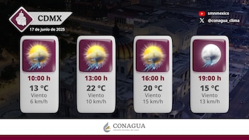
According to the SMN, a mostly cloudy sky is expected throughout the day, with intermittent rainfall likely to intensify between 2:00 PM and 10:00 PM. These showers will be accompanied by lightning, strong gusts of wind, and reduced visibility on some roads.
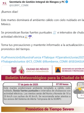
Additionally, the Secretariat of Integral Risk Management and Civil Protection (SGIRPC) warned about the possibility of flooding, landslides, and rising rivers or streams, especially in areas with slopes or inadequate drainage.
The conditions are expected to remain cool, so it is advisable to dress warmly and carry an umbrella if you plan to be outdoors.
- Mexico City:
- Minimum temperature: between 13 and 15 °C
- Maximum temperature: between 20 and 22 °C
- Toluca, State of Mexico:
- Minimum: between 9 and 11 °C
- Maximum: between 17 and 19 °C
If you want to know where it is currently raining, you can consult the real-time map of pluviometric stations provided by the Water System of Mexico City (SEGIAGUA). This tool allows you to visualize areas with active precipitation by borough.
You can access the map via this link: Pluviometric Stations Map.
According to the first reports of the day (by 7:00 AM), rain had already been recorded in Miguel Hidalgo and Álvaro Obregón, leading to expectations that other boroughs such as Iztapalapa, Tlalpan, Cuauhtémoc, and Benito Juárez might also experience showers as the afternoon progresses.
Furthermore, it is noteworthy that in the past few days, the rainfall has caused significant disruptions, with over 137 reported flooding incidents and more than 60 fallen trees in various areas of the capital. Boroughs such as Azcapotzalco, Benito Juárez, Iztacalco, Miguel Hidalgo, and Iztapalapa have been among the most affected.
- Avoid littering in public spaces to prevent blocking drainage systems.
- Do not seek shelter under trees or metal structures during thunderstorms.
- Drive cautiously with your lights on during heavy rainfall.
In summary, the ongoing rainfall in Mexico City and surrounding regions is expected to continue, reinforcing the importance of being prepared for potential flooding and hazardous conditions. By staying informed through official channels and taking preventive measures, residents can help mitigate the risks associated with this extreme weather event. Careful planning and awareness are essential for navigating these challenging conditions safely.
General News – 2