

The tropical storm Erick is intensifying over the Pacific Ocean, posing a growing threat to the southern and southwestern states of Mexico. According to the National Meteorological Service (SMN) , as of 3:00 AM local time, the tropical depression Five-E has evolved into a tropical storm, moving northwest at a speed of 19 km/h. The storm is accompanied by intense rainfall and sustained winds of up to 65 km/h , with gusts reaching 85 km/h .
At 3:00 AM, the center of Erick was located 335 kilometers southwest of Puerto Chiapas, Chiapas , and 725 kilometers southeast of Punta Maldonado, Guerrero . With forecasts indicating a rapid increase in intensity, Erick may reach hurricane status before making landfall on the coast of Guerrero.
The system has prompted the issuance of safety advisories by federal authorities: one for hurricane effects from Bahías de Huatulco, Oaxaca, to Punta Maldonado, Guerrero , and another for tropical storm effects from Salina Cruz to Bahías de Huatulco , both along the Oaxacan coast.
Rainfall predictions for the period from June 17 to June 18 anticipate accumulations of up to 150 mm in states such as Guerrero, Oaxaca, Chiapas, and southern Veracruz , raising concerns about potential landslides, flash floods , and rising rivers and streams in low-lying areas. Very heavy rains are also forecasted for southern Puebla, along with substantial precipitation in Tabasco.
In addition to rainfall, a wave height of between 2.5 and 3.5 meters is expected, along with wind gusts of up to 70 km/h along the coastlines of Oaxaca and Chiapas. These conditions are projected to intensify as the storm advances northwestward.
Should the intensity remain as projected, the system is expected to reach Category 1 hurricane status by June 18 at 12:00 PM , further intensifying to Category 2 by the morning of June 19, when it is forecasted to be located just 75 km south of Lagunas de Chacahua, Oaxaca .
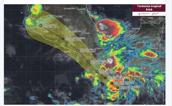
Afterward, the cyclone is expected to make landfall on June 19 around noon, approximately 70 km northwest of Punta Maldonado, Guerrero , still at Category 2 hurricane strength , with maximum sustained winds of 160 km/h and gusts reaching 195 km/h . By June 20, as it moves inland, it is predicted to weaken back to a tropical storm, positioned 95 km northeast of Zihuatanejo , and ultimately degrade to remnant low pressure on June 21, about 110 km northeast of Manzanillo, Colima .