
Severe storms are forecasted to sweep across Germany today. Locally, storms, high rain amounts, hail, and even hurricane-force gusts are possible. Here’s a comprehensive overview along with a live map .
Frankfurt am Main – The summer months are notorious for increased severe weather , a trend that seems to be substantiated according to forecasts for Wednesday. Throughout the day, it’s expected that the weather may become particularly unpleasant, with forecasts indicating potential severe thunderstorms, hurricane-force gusts, and intense rainfall. A closer look reveals what areas might be hardest hit and which areas may remain unaffected, according to the Ippen.Media weather map.
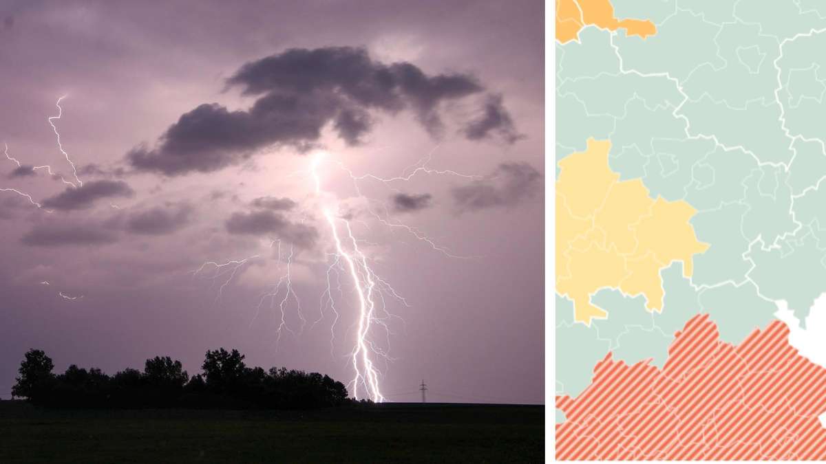
Current Severe Weather: Live Map Showing Thunderstorm, Hail, and Rain Updates
The German Weather Service (DWD) anticipates the arrival of severe thunderstorms moving from west to east during the afternoon. Meteorologists warn of hail sizes of about five centimeters in diameter and localized severe gusts of wind up to 100 kilometers per hour .
Today, the DWD predicts that areas will experience noteworthy rainfall, estimating precipitation between 25 to 40 liters per square meter . Furthermore, experts warn that there could be extreme thunderstorms with hailstones of up to eight centimeters in diameter and hurricane-force winds exceeding 120 kilometers per hour . “The combination of these wind speeds and large hail presents a high risk of damage to people, infrastructure, and nature,” emphasizes the DWD in their storm warning.
Thunderstorms and Hail: Areas Under Current Weather Warnings
On Tuesday, Dominik Jung from wetter.net already alerted the public to potential dangers, including storm surges expected during the potentially severe storms on Wednesday. The forecast indicates that large parts of Baden-Württemberg and Bavaria will be significantly affected, along with southern Thuringia , reaching as far north as Erfurt , substantial areas of Saxony-Anhalt , southwestern Lower Saxony , and southern Mecklenburg-Vorpommern .
Additionally, severe thunderstorms are expected to pass from Rhineland-Palatinate and Saarland through Hesse , extending to northern Saxony , Brandenburg , and Berlin , with gusts of wind reaching 85 km/h and rainfall up to 25 liters in a short period.
Recommended Precautions by the German Weather Service
Given the severe weather anticipated with hurricane-force winds, the DWD has provided several recommendations for citizens. Hazards from severe storms include:
- Fallen trees, high-voltage lines, scaffolding, and various objects
- Damaged roofs
- Flying debris
Thus, meteorologists strongly advise that affected individuals take action such as:
- Securing or removing outdoor items if possible
- Avoiding outdoor activities and seeking safety indoors
- Keeping a significant distance from buildings, trees, scaffolding, and high-voltage lines
- Closing windows and doors
- Anticipating substantial disruptions on transportation routes
- Being prepared for potential power and mobile network outages
- Monitoring the risk levels and weather warnings
- Informing others about the ongoing situation
It is essential to note that the DWD expects some of the heavy thunderstorms to move eastward during the early night hours into Thursday. Citizens should remain aware that this preliminary information may be subject to change throughout the day.