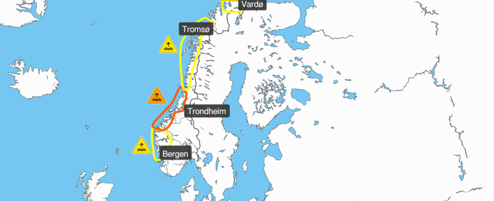
A low pressure is moving towards Norway from the North Atlantic on Friday. It brings rainfall to most areas of the country. Yellow danger warnings were sent out on Friday, for both snow in parts of Vestland and Trøndelag, and strong wind in the outer regions of Møre og Romsdal and Sogn og Fjordane. Your browser does not support embedding external content – It’s already blown up to a small storm along the coast, so it’s probably going to blow quite a bit. As if that wasn’t enough, we also get snow in several places, and periodic hailstorms and thunder, says meteorologist on duty at the Meteorological Institute, Leonidas Tsopouridis. These danger warnings have been sent out for the weekend: Orange danger warning: Very high water level in coastal and fjord areas in Møre and Romsdal and Trøndelag (09.00–13.00 Saturday and from 21.00 Saturday to 01.00 Sunday) Yellow danger warning: High water level in coastal and fjord areas in the South -Troms (from Friday 11pm to Saturday 2am and Sunday 12–15) High water level in coastal and fjord areas in Hordaland and Sogn og Fjordane (Saturday 09.00–13.00 and from Saturday 21.00 to Sunday 01.00) High water level in coastal and fjord areas in Nordland south of Bodø, Vestfjorden, western part of Lofoten and coastal and fjord areas in Troms (Saturday 10am–2pm and from Saturday 10 p.m. to 2 a.m. Sunday) High water level in coastal and fjord areas in East Finnmark (Saturday 2 p.m.–6.30 p.m. and Sunday 02 a.m.–3 p.m.) Heavy snow in the mountains in southern Norway (from Saturday at 01 to Sunday at 1 p.m.) Snow in parts of Vestlandet and Trøndelag (03 a.m. to 3 p.m. Saturday) Strong gusts of wind in outer areas of Møre og Romsdal and Sogn og Fjordane (from 13–20 on Saturday) In addition, these danger warnings are active: Orange danger warning for soil, slush and flood avalanche danger in parts of Nordland and southern Troms (until Saturday at 14) Orange danger warning for flood danger in Ofoten and Nordland north of Rana (until Saturday at 2 p.m.) Yellow danger warning for soil, slush and flood avalanche danger in parts of Nordland and southern parts of Troms (until Saturday at 2 p.m.) Yellow danger warning for flood risk in parts of Nordland and Sør-Troms (until Saturday at 2 p.m.) Yellow warning for heavy rain in parts of Nordland and Sør-Troms (until until Saturday at 10 a.m.) Yellow warning for high water levels in coastal and fjord areas in Eastern Finnmark until Friday at 17.30. From before, very high water levels are also expected along the coast. – The supermoon will be close to the Earth and draw in the water in the sea, which in turn produces higher tides, explains Tsopouridis. Snow is expected in several places in the country this weekend. Photo: Meteorologists Setting up flood defenses in Bergen To avoid flooding at Bryggen, the municipality will now install flood fences. The municipal director in Bergen has decided that. – A possible storm surge has been reported. The fire service must deploy flood defenses to ensure that the wave crests do not come inland and flow into Bryggen, says Dan Inge Gjesdal, duty commander in the 110 center West. The fire service will try to prevent this from happening again. The picture is from flooding along Bryggen in Bergen in 2020. Photo: Ingvild Ulset / news One section of the road between Bradbenken 2 and Bryggen 23 will therefore be closed until Sunday afternoon, the fire service says. Water + cold = challenging driving conditions Meteorologists recommend allowing extra time if you are going out on the road. Both at the weekend and on Monday. – This is definitely the weekend for “Netflix & chill”, says Tsopouridis. Yellow danger level Yellow is used for a moderately dangerous situation, which can cause damage locally. Yellow danger alerts are sent out when minor consequences are expected. Most people will be able to continue their daily tasks, but those who, e.g. planning outdoor activities, should be aware or possibly stay inside. There may be damage locally Power cuts may occur Traffic delays are likely Wind can make it dangerous to be in the mountains Read more about different levels of danger. Orange danger level If an orange level is reported, you must take it very seriously. This is something that does not happen often, and it means great danger. Prepare for serious consequences, and think twice if you plan to stay in the area in question. The weather can lead to serious damage The consequences will be great for many Real danger that lives and valuables may be lost Roads closed, boats grounded, planes etc. During Sunday both the water level will be lower and the strength of the gusts less, he assures. – But it will also be significantly colder, and the precipitation will turn to snow. So there will be some “yo-yo weather” in the next few days, and people must be prepared for challenging driving conditions and slippery roads on Monday, he adds. Published 15.11.2024, at 14.38 Updated 15.11.2024, at 14.58
ttn-69
The fire service in Bergen sets up flood protection at Bryggen – news Vestland

