
The Urgency of Desertification in Spain
For years, desertification has loomed over the Iberian Peninsula as an impending threat. Fortunately, recent advancements in data science and collaborative efforts from the University of Alicante (UA) and the CSIC have transformed this narrative. We can now confront tangible realities, forcing us to rethink our environmental strategies.
The Latest Findings
The First Atlas of Desertification of Spain (ADE) offers a comprehensive analysis of the degradation of Spanish soil, derived from decades of accumulated data. The findings are alarming: over 40% of the national territory is undergoing various stages of degradation. This figure does not merely signify future concerns; it highlights an ongoing crisis masked by technological interventions in agriculture.
The Reality of Soil Health
Understanding soil degradation requires debunking the myth that desertification equates to transforming Spain into a barren desert like the Sahara. According to project coordinators Jorge Olcina (UA) and Jaime Martínez Valderrama (CSIC), desertification refers to the degradation of land in dry regions, resulting in diminished biological and economic productivity.
Staggering Statistics
Current data shows that 40.9% of Spain is exhibiting signs of soil degradation. In drier zones—arid, semi-arid, and dry subhumid areas—this percentage rises to an alarming 60.94%. These statistics highlight the rigorous assessment that the Atlas provides, confirming that Spain is not just on the verge of desertification; it is already experiencing severe impacts.
The Irrigation Paradox
While agricultural technology aims to combat desertification, the findings indicate that extensive irrigation may inadvertently accelerate the very problem it seeks to solve. Intensively irrigated lands often utilize fertilizers and drain groundwater reserves, leading to misleadingly thriving crops while jeopardizing true soil health.
Impact of Agricultural Practices
The Atlas correlates chlorophyll and biomass data with water resource status, revealing that current agricultural practices may deplete aquifers and salt the soil. For example, in the Guadiana basin, a staggering 86% of aquifers are overexploited or degraded. The emphasis on maintaining “green” surfaces obscures deeper, more concerning realities.
Regional Insights
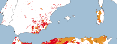
With more than 60 thematic maps created using Big Data and Artificial Intelligence, the Atlas pinpoints areas severely affected by desertification. Key regions include:
- Region of Murcia: The most impacted area, facing extreme water pressure and growing aridity.
- Valencian Community and Andalusia: Both regions have large swathes of intensive cultivation amidst high climatic vulnerability.
- Canary Islands: An island location complicates land management risks.
- La Mancha and Aragón: These areas, though often overlooked, are experiencing rapid degradation due to agricultural changes.
Changing the Narrative
The ADE has overhauled previous, outdated mapping by integrating socioeconomic variables to assess water usage comprehensively. Alarmingly, 42% of Spain’s territory consumes over 80% of its available fresh water. Given the realities of climate change—with erratic rainfall and rising temperatures—this model is unsustainable and requires urgent reevaluation.