
Understanding the Meteorological Phenomenon
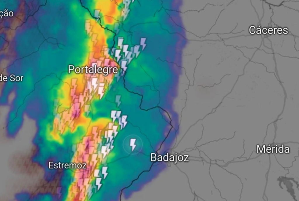
On the morning of November 5, a cold front swept across the Peninsula, inciting a remarkably active squall line in the southwest. The term “very active” hardly does justice to the ferocity of the storms. Reports and images from Portugal illustrate the chaotic nature of this weather event, with the storm system advancing towards Extremadura and Western Andalusia.
What Exactly is a Squall Line?
A squall line is characterized as an organized storm system that frequently forms in a line ahead of a cold front. Such systems are known for unleashing strong winds, torrential rains, hail, and frequent lightning strikes. The speed at which these storms move contributes to their potential to cause significant damage.
The Impact of the Storm
Portugal’s Civil Protection reported over 150 incidents linked to the storm, not merely due to the rain and wind, but also because of the staggering count of around 30,000 lightning strikes during just a few hours. This high frequency of electrical discharges can trigger various hazards, from power outages to fires.
Alerts and Preparations
In response, AEMET issued orange alerts for Galicia, Extremadura, and Andalusia. The agency prepared for rainfalls of 5 to 20 liters per square meter in very brief periods. While this may not seem like a significant amount, under the circumstances, it poses serious risks to both infrastructure and public safety.
Distinguishing Between Typical Weather Patterns and Severe Events
This isn’t a case of typical autumn rains. Rather, we are witnessing organized convection capable of producing severe gusts, hail, and what meteorologists refer to as “wet downbursts.” These conditions heighten the risk to urban areas, electrical networks, and overall mobility.
The Emergence of a New Normal
This wave of extreme weather is a continuation of a trend that has been playing out over the past weeks—a pattern that can no longer be attributed solely to typical Atlantic storms. November generally sees southwest airflows, yet the alarming data suggest we may be facing a new normal.
What’s Behind These Severe Weather Events?
The underlying causes include the arrival of an Atlantic trough and cold front that introduces sufficient shear to generate convective systems. The role of ambient humidity cannot be overstated; it serves as a catalyst for these storms.
Future Trends
As connections with the Gulf of Mexico become increasingly common—often described as “rivers of moisture”—the increased humidity levels will likely lead to more frequent and intense weather systems. This parallels the way DANAs affect the Mediterranean region, suggesting that climate change may intensify these patterns. The availability of “fuel” in the atmosphere means that even a minor trigger could escalate into a major storm.
As we observe these changes, it becomes crucial to adapt our understanding and responses to weather patterns. The squall line phenomenon is no longer just a term; it signifies a growing trend in severe weather that we must prepare for.
Image credit: Carlos Virazón