

Spain’s Unusual Weather: A Sudden Shift from Spring to Winter
After an unprecedented April in Spain, marked by temperatures exceeding three degrees above the average for the last 40 years, the weather is set to take an unexpected turn. A deep storm is making its way from the Icelandic region towards Spain, predicted to cause a significant thermal drop between Saturday, May 9, and Monday, May 11.
Are We Experiencing a Cold Wave in May?
Despite the dramatic shift in temperatures, this isn’t a “cold wave” in the traditional sense. Rather, it’s a typical maritime polar air movement seen during Spanish springs. The unusual aspect is not the arrival of colder air, but how unseasonably warm the preceding temperatures have been.
We are indeed going to experience a thermal drop; however, this reaction stems more from our acclimatization to high temperatures than from an anomalously cold storm system. The storm is not the problem; our expectations and norms are.
The Bigger Picture: Climate Change Impact
The crux of the issue lies in climate change. Present data suggests that while climate change does not increase the frequency of polar incursions in May, it does amplify their potential consequences. Events like advanced flowering, budding, and fruit set can be severely affected.
This raises a paradox: the same cold weather as in previous years could now lead to significant agricultural destruction. The conditions are ripe for catastrophic impacts if not managed properly.
What to Expect in the Coming Days
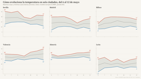
- Wednesday 6: The DANA affecting the region will begin moving towards France, integrating into the general circulation.
- Thursday 7 – Friday 8: A new cold storm will impact western Portugal, leading to “very warm for the season” temperatures, as noted by AEMET.
- Friday 8: An Atlantic front will approach the Peninsula, initiating stormy weather patterns in the north, though expected accumulations won’t be dramatic.
- Saturday 9 – Sunday 10: The storm’s arrival will markedly drop temperatures abruptly, with a predicted decline of 8 to 10 degrees.
- Starting Monday 11: Cold conditions are expected to linger, but specific predictions remain tentative.
A Note from AEMET
AEMET characterizes this instability clearly: it does not use the term “polar” but describes the change as a transition from “high temperatures for the season” to a “winter atmosphere” within a mere 24-48 hours. This stark contrast underscores the unpredictable nature of current weather patterns.
As we navigate this unusual climatic landscape, experts warn that the events of 2026 may present challenges we’ve yet to fully grasp.
Image credit: BenBaso
For further insights, explore how warming currents affecting Europe are predicted to weaken significantly by the end of the century, with Spain already witnessing early signs of these changes.